Châteaubriant geodata
Châteaubriant (Pays de la Loire) is a seat of a third-order administrative division; located in France in Europe/Paris (GMT+2) time zone. With population of 13,024 people, there are 733 cities with bigger population in this country. Compared to other cities in France, 54.5% of cities are located further ↓South; 91.3% of cities are located further →East and 75% of cities have higher elevation than Châteaubriant. Note1
Administrative division(s):
- Level 1: Pays de la Loire
- Level 2: Loire-Atlantique
- Level 3: Arrondissement of Châteaubriant-Ancenis
- Level 4: Châteaubriant


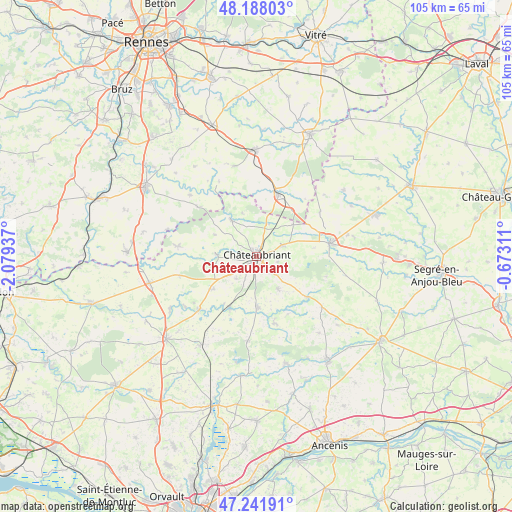
Châteaubriant GPS coordinates[2]
47° 43' 1.632" North, 1° 22' 34.464" West
| Map corner | latitude | longitude |
|---|---|---|
| Upper-left | 48.18803°, | -2.07937° |
| Center: | 47.71712°, | -1.37624° |
| Lower-right: | 47.24191°, | -0.67311° |
| Map W x H: | 105.2×105.2 km | = 65.4×65.4mi |
| max Lat: | 51.07786° ⇑45.5% North |
| Châteaubriant: | 47.71712° |
| min Lat: | ⇓54.5% South 41.3874° |
| min Long | Châteaubriant | max Long |
| -5.08615° | -1.37624° | 9.52242° |
| W 8.7%⇐ | ⇒91.3% E |
Elevation
Elevation of Châteaubriant is 67 m = 220 ft, and this is 126.7 m = 416 ft below average elevation for this country.
| Max E: |
2333 m = 7654 ft | 75% |
| Avg. | 193.7 m = 635 ft | |
| Châteaubriant | 67 m = 220 ft | |
Min E: |
-1 m = -3 ft | 25% |
See also: France elevation on elevation.city.
Geographical zone
Châteaubriant is located in North temperate zone (between Tropic of Cancer and the Arctic Circle). Distance of this North polar circle is 2095.5 km =1302.1 mi to North.| Distance of | km | miles | from Châteaubriant |
|---|---|---|---|
| North Pole | 4701.4 | 2921.3 | to North |
| Arctic Circle | 2095.5 | 1302.1 | to North |
| Tropic Cancer | 2699.7 | 1677.5 | to South |
| Equator | 5305.6 | 3296.7 | to South |


Nearby cities:
15 places around Châteaubriant: (largest is in red/bold)
• Erbray
8.2 km =5.1 mi,  147°
147°
• Fercé
9.2 km =5.7 mi,  340°
340°
• Issé
11.8 km =7.3 mi,  208°
208°
• Louisfert
6.3 km =3.9 mi,  222°
222°
• Martigné-Ferchaud
13.2 km =8.2 mi,  18°
18°
• Moisdon-la-Rivière
10.6 km =6.6 mi,  178°
178°
• Noyal-sur-Brutz
6.8 km =4.2 mi, 18°
• Pouancé
15.4 km =9.6 mi,  79°
79°
• Rougé
9.1 km =5.7 mi,  324°
324°
• Ruffigné
9.9 km =6.2 mi,  296°
296°
• Saint-Aubin-des-Châteaux
8.4 km =5.2 mi,  272°
272°
• Saint-Julien-de-Vouvantes
13.2 km =8.2 mi,  129°
129°
• Saint-Vincent-des-Landes
11.2 km =7 mi,  233°
233°
• Soudan
5.8 km =3.6 mi,  66°
66°
• Villepot
9.8 km =6.1 mi,  48°
48°
Sources, notices
• [Note1] Compared only with cities in France existing in our database
• [Src1] Map data: © OpenStreetMap contributors (CC-BY-SA)
• [Src2] Other city data from geonames.org with taken over terms of usage.
• [Src3] Geographical zone / Annual Mean Temperature by Robert A. Rohde @ Wikipedia
