Fercé geodata
Fercé (Pays de la Loire) is a populated place; located in France in Europe/Paris (GMT+2) time zone. With population of 559 people, there are 14019 cities with bigger population in this country. Compared to other cities in France, 55.6% of cities are located further ↓South; 91.6% of cities are located further →East and 65.6% of cities have higher elevation than Fercé. Note1
Administrative division(s):
- Level 1: Pays de la Loire
- Level 2: Loire-Atlantique
- Level 3: Arrondissement of Châteaubriant-Ancenis
- Level 4: Fercé


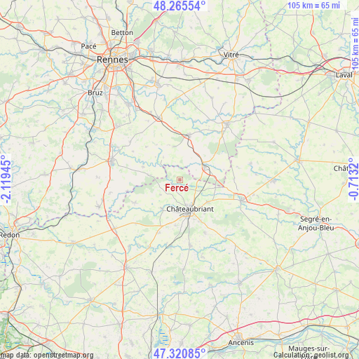
Fercé GPS coordinates[2]
47° 47' 43.224" North, 1° 24' 58.788" West
| Map corner | latitude | longitude |
|---|---|---|
| Upper-left | 48.26554°, | -2.11945° |
| Center: | 47.79534°, | -1.41633° |
| Lower-right: | 47.32085°, | -0.7132° |
| Map W x H: | 105×105 km | = 65.2×65.2mi |
| max Lat: | 51.07786° ⇑44.4% North |
| Fercé: | 47.79534° |
| min Lat: | ⇓55.6% South 41.3874° |
| min Long | Fercé | max Long |
| -5.08615° | -1.41633° | 9.52242° |
| W 8.4%⇐ | ⇒91.6% E |
Elevation
Elevation of Fercé is 88 m = 289 ft, and this is 105.7 m = 347 ft below average elevation for this country.
| Max E: |
2333 m = 7654 ft | 65.6% |
| Avg. | 193.7 m = 635 ft | |
| Fercé | 88 m = 289 ft | |
Min E: |
-1 m = -3 ft | 34.4% |
See also: France elevation on elevation.city.
Geographical zone
Fercé is located in North temperate zone (between Tropic of Cancer and the Arctic Circle). Distance of this North polar circle is 2086.8 km =1296.7 mi to North.| Distance of | km | miles | from Fercé |
|---|---|---|---|
| North Pole | 4692.7 | 2915.9 | to North |
| Arctic Circle | 2086.8 | 1296.7 | to North |
| Tropic Cancer | 2708.4 | 1682.9 | to South |
| Equator | 5314.3 | 3302.2 | to South |


Nearby cities:
15 places around Fercé: (largest is in red/bold)
• Châteaubriant
9.2 km =5.7 mi,  160°
160°
• Coësmes
9.9 km =6.2 mi,  349°
349°
• Ercé-en-Lamée
11.3 km =7 mi,  290°
290°
• Lalleu
9.7 km =6 mi,  313°
313°
• Louisfert
13.4 km =8.3 mi,  185°
185°
• Martigné-Ferchaud
8.2 km =5.1 mi,  62°
62°
• Noyal-sur-Brutz
5.7 km =3.5 mi,  113°
113°
• Retiers
13.5 km =8.4 mi,  11°
11°
• Rougé
2.7 km =1.7 mi,  240°
240°
• Ruffigné
7.2 km =4.5 mi,  233°
233°
• Saint-Aubin-des-Châteaux
9.9 km =6.2 mi,  213°
213°
• Soudan
10.5 km =6.5 mi,  127°
127°
• Teillay
9.3 km =5.8 mi,  278°
278°
• Thourie
8.2 km =5.1 mi,  324°
324°
• Villepot
10.6 km =6.6 mi,  102°
102°
Sources, notices
• [Note1] Compared only with cities in France existing in our database
• [Src1] Map data: © OpenStreetMap contributors (CC-BY-SA)
• [Src2] Other city data from geonames.org with taken over terms of usage.
• [Src3] Geographical zone / Annual Mean Temperature by Robert A. Rohde @ Wikipedia
