Noyal-sur-Brutz geodata
Noyal-sur-Brutz (Pays de la Loire) is a populated place; located in France in Europe/Paris (GMT+2) time zone. With population of 529 people, there are 14624 cities with bigger population in this country. Compared to other cities in France, 55.4% of cities are located further ↓South; 91.1% of cities are located further →East and 68.3% of cities have higher elevation than Noyal-sur-Brutz. Note1
Administrative division(s):
- Level 1: Pays de la Loire
- Level 2: Loire-Atlantique
- Level 3: Arrondissement of Châteaubriant-Ancenis
- Level 4: Noyal-sur-Brutz


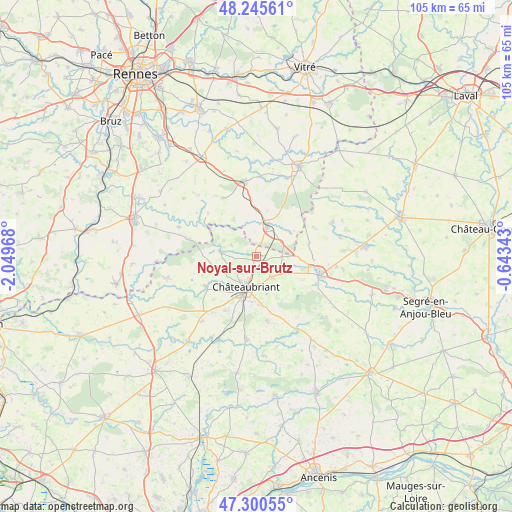
Noyal-sur-Brutz GPS coordinates[2]
47° 46' 30.828" North, 1° 20' 47.58" West
| Map corner | latitude | longitude |
|---|---|---|
| Upper-left | 48.24561°, | -2.04968° |
| Center: | 47.77523°, | -1.34655° |
| Lower-right: | 47.30055°, | -0.64343° |
| Map W x H: | 105.1×105.1 km | = 65.3×65.3mi |
| max Lat: | 51.07786° ⇑44.6% North |
| Noyal-sur-Brutz: | 47.77523° |
| min Lat: | ⇓55.4% South 41.3874° |
| min Long | Noyal-sur-Brutz | max Long |
| -5.08615° | -1.34655° | 9.52242° |
| W 8.9%⇐ | ⇒91.1% E |
Elevation
Elevation of Noyal-sur-Brutz is 82 m = 269 ft, and this is 111.7 m = 366 ft below average elevation for this country.
| Max E: |
2333 m = 7654 ft | 68.3% |
| Avg. | 193.7 m = 635 ft | |
| Noyal-sur-Brutz | 82 m = 269 ft | |
Min E: |
-1 m = -3 ft | 31.7% |
See also: France elevation on elevation.city.
Geographical zone
Noyal-sur-Brutz is located in North temperate zone (between Tropic of Cancer and the Arctic Circle). Distance of this North polar circle is 2089.1 km =1298.1 mi to North.| Distance of | km | miles | from Noyal-sur-Brutz |
|---|---|---|---|
| North Pole | 4695 | 2917.3 | to North |
| Arctic Circle | 2089.1 | 1298.1 | to North |
| Tropic Cancer | 2706.2 | 1681.6 | to South |
| Equator | 5312.1 | 3300.8 | to South |


Nearby cities:
15 places around Noyal-sur-Brutz: (largest is in red/bold)
• Châteaubriant
6.8 km =4.2 mi,  198°
198°
• Coësmes
13.9 km =8.6 mi,  329°
329°
• Erbray
13.5 km =8.4 mi,  170°
170°
• Fercé
5.7 km =3.5 mi,  293°
293°
• Lalleu
15.2 km =9.4 mi,  305°
305°
• Louisfert
12.9 km =8 mi,  210°
210°
• Martigné-Ferchaud
6.4 km =4 mi,  18°
18°
• Pouancé
13.5 km =8.4 mi,  106°
106°
• Rougé
7.6 km =4.7 mi,  277°
277°
• Ruffigné
11.2 km =7 mi,  259°
259°
• Saint-Aubin-des-Châteaux
12.3 km =7.6 mi,  240°
240°
• Soudan
5.2 km =3.2 mi,  143°
143°
• Teillay
14.9 km =9.3 mi, 284°
• Thourie
13.4 km =8.3 mi, 311°
• Villepot
5.1 km =3.2 mi,  89°
89°
Sources, notices
• [Note1] Compared only with cities in France existing in our database
• [Src1] Map data: © OpenStreetMap contributors (CC-BY-SA)
• [Src2] Other city data from geonames.org with taken over terms of usage.
• [Src3] Geographical zone / Annual Mean Temperature by Robert A. Rohde @ Wikipedia
