Soudan geodata
Soudan (Pays de la Loire) is a populated place; located in France in Europe/Paris (GMT+2) time zone. With population of 2,199 people, there are 4368 cities with bigger population in this country. Compared to other cities in France, 54.8% of cities are located further ↓South; 90.8% of cities are located further →East and 70.1% of cities have higher elevation than Soudan. Note1
Administrative division(s):
- Level 1: Pays de la Loire
- Level 2: Loire-Atlantique
- Level 3: Arrondissement of Châteaubriant-Ancenis
- Level 4: Soudan


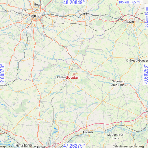
Soudan GPS coordinates[2]
47° 44' 15.972" North, 1° 18' 20.376" West
| Map corner | latitude | longitude |
|---|---|---|
| Upper-left | 48.20849°, | -2.00878° |
| Center: | 47.73777°, | -1.30566° |
| Lower-right: | 47.26275°, | -0.60253° |
| Map W x H: | 105.2×105.2 km | = 65.4×65.4mi |
| max Lat: | 51.07786° ⇑45.2% North |
| Soudan: | 47.73777° |
| min Lat: | ⇓54.8% South 41.3874° |
| min Long | Soudan | max Long |
| -5.08615° | -1.30566° | 9.52242° |
| W 9.2%⇐ | ⇒90.8% E |
Elevation
Elevation of Soudan is 78 m = 256 ft, and this is 115.7 m = 380 ft below average elevation for this country.
| Max E: |
2333 m = 7654 ft | 70.1% |
| Avg. | 193.7 m = 635 ft | |
| Soudan | 78 m = 256 ft | |
Min E: |
-1 m = -3 ft | 29.9% |
See also: France elevation on elevation.city.
Geographical zone
Soudan is located in North temperate zone (between Tropic of Cancer and the Arctic Circle). Distance of this North polar circle is 2093.2 km =1300.7 mi to North.| Distance of | km | miles | from Soudan |
|---|---|---|---|
| North Pole | 4699.1 | 2919.9 | to North |
| Arctic Circle | 2093.2 | 1300.7 | to North |
| Tropic Cancer | 2702 | 1678.9 | to South |
| Equator | 5307.9 | 3298.2 | to South |


Nearby cities:
15 places around Soudan: (largest is in red/bold)
• Chazé-Henry
14.6 km =9.1 mi,  83°
83°
• Châteaubriant
5.8 km =3.6 mi,  246°
246°
• Erbray
9.3 km =5.8 mi,  185°
185°
• Fercé
10.5 km =6.5 mi,  307°
307°
• La Chapelle-Glain
15.3 km =9.5 mi,  147°
147°
• Louisfert
11.8 km =7.3 mi,  233°
233°
• Martigné-Ferchaud
10.2 km =6.3 mi,  354°
354°
• Moisdon-la-Rivière
13.8 km =8.6 mi,  201°
201°
• Noyal-sur-Brutz
5.2 km =3.2 mi,  323°
323°
• Pouancé
9.9 km =6.2 mi,  87°
87°
• Rougé
11.8 km =7.3 mi,  295°
295°
• Ruffigné
14.3 km =8.9 mi,  278°
278°
• Saint-Aubin-des-Châteaux
13.8 km =8.6 mi,  262°
262°
• Saint-Julien-de-Vouvantes
11.7 km =7.3 mi,  155°
155°
• Villepot
4.7 km =2.9 mi,  26°
26°
Sources, notices
• [Note1] Compared only with cities in France existing in our database
• [Src1] Map data: © OpenStreetMap contributors (CC-BY-SA)
• [Src2] Other city data from geonames.org with taken over terms of usage.
• [Src3] Geographical zone / Annual Mean Temperature by Robert A. Rohde @ Wikipedia
