Marsat geodata
Marsat (Auvergne-Rhône-Alpes) is a populated place; located in France in Europe/Paris (GMT+2) time zone. With population of 1,203 people, there are 7511 cities with bigger population in this country. Compared to other cities in France, 68% of cities are located further ↑North; 59% of cities are located further ←West and 87.4% of cities have lower elevation than Marsat. Note1
Administrative division(s):
- Level 1: Auvergne-Rhône-Alpes
- Level 2: Département du Puy-de-Dôme
- Level 3: Arrondissement de Riom
- Level 4: Marsat


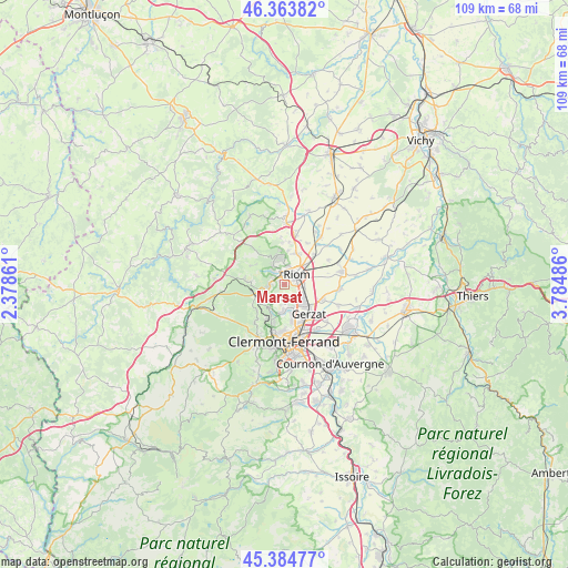
Marsat GPS coordinates[2]
45° 52' 35.22" North, 3° 4' 54.228" East
| Map corner | latitude | longitude |
|---|---|---|
| Upper-left | 46.36382°, | 2.37861° |
| Center: | 45.87645°, | 3.08173° |
| Lower-right: | 45.38477°, | 3.78486° |
| Map W x H: | 108.9×108.9 km | = 67.7×67.7mi |
| max Lat: | 51.07786° ⇑68% North |
| Marsat: | 45.87645° |
| min Lat: | ⇓32% South 41.3874° |
| min Long | Marsat | max Long |
| -5.08615° | 3.08173° | 9.52242° |
| W 59%⇐ | ⇒41% E |
Elevation
Elevation of Marsat is 380 m = 1247 ft, and this is 186.3 m = 611 ft above average elevation for this country.
| Max E: |
2333 m = 7654 ft | 12.6% |
| Marsat | 380 m 1247 ft | |
| Avg. | 193.7 m = 635 ft | |
Min E: |
-1 m = -3 ft | 87.4% |
See also: France elevation on elevation.city.
Geographical zone
Marsat is located in North temperate zone (between Tropic of Cancer and the Arctic Circle). Distance of this North polar circle is 2300.2 km =1429.3 mi to North.| Distance of | km | miles | from Marsat |
|---|---|---|---|
| North Pole | 4906.1 | 3048.5 | to North |
| Arctic Circle | 2300.2 | 1429.3 | to North |
| Tropic Cancer | 2495.1 | 1550.4 | to South |
| Equator | 5101 | 3169.6 | to South |


Nearby cities:
15 places around Marsat: (largest is in red/bold)
• Blanzat
5.2 km =3.2 mi,  183°
183°
• Chanat-la-Mouteyre
7.2 km =4.5 mi,  225°
225°
• Charbonnières-les-Varennes
7.2 km =4.5 mi,  298°
298°
• Châteaugay
2.8 km =1.7 mi, 175°
• Châtel-Guyon
5.3 km =3.3 mi,  345°
345°
• Cébazat
5.2 km =3.2 mi,  164°
164°
• Enval
3.5 km =2.2 mi,  315°
315°
• Gerzat
7.5 km =4.7 mi,  139°
139°
• Malauzat
3.9 km =2.4 mi,  214°
214°
• Mozac
2.2 km =1.4 mi,  28°
28°
• Ménétrol
3.3 km =2.1 mi,  99°
99°
• Riom
3.1 km =1.9 mi,  51°
51°
• Saint-Bonnet-près-Riom
6.4 km =4 mi,  22°
22°
• Sayat
6 km =3.7 mi,  202°
202°
• Volvic
3.4 km =2.1 mi,  261°
261°
Sources, notices
• [Note1] Compared only with cities in France existing in our database
• [Src1] Map data: © OpenStreetMap contributors (CC-BY-SA)
• [Src2] Other city data from geonames.org with taken over terms of usage.
• [Src3] Geographical zone / Annual Mean Temperature by Robert A. Rohde @ Wikipedia
