Châtel-Guyon geodata
Châtel-Guyon (Auvergne-Rhône-Alpes) is a populated place; located in France in Europe/Paris (GMT+2) time zone. With population of 5,681 people, there are 1742 cities with bigger population in this country. Compared to other cities in France, 67.3% of cities are located further ↑North; 58.7% of cities are located further ←West and 89.8% of cities have lower elevation than Châtel-Guyon. Note1
Administrative division(s):
- Level 1: Auvergne-Rhône-Alpes
- Level 2: Département du Puy-de-Dôme
- Level 3: Arrondissement de Riom
- Level 4: Châtel-Guyon


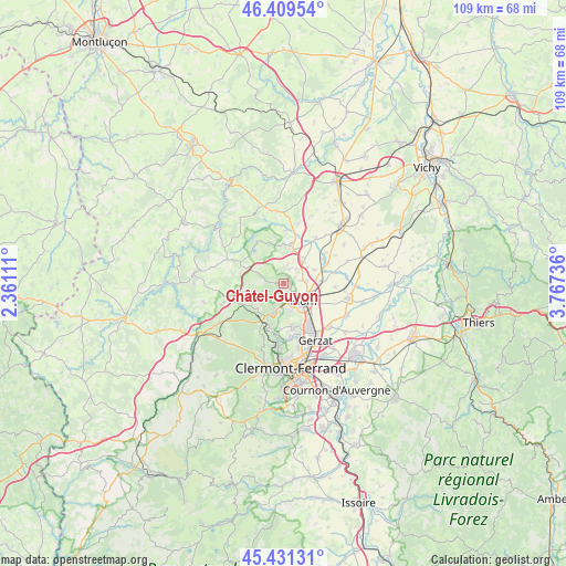
Châtel-Guyon GPS coordinates[2]
45° 55' 21.288" North, 3° 3' 51.228" East
| Map corner | latitude | longitude |
|---|---|---|
| Upper-left | 46.40954°, | 2.36111° |
| Center: | 45.92258°, | 3.06423° |
| Lower-right: | 45.43131°, | 3.76736° |
| Map W x H: | 108.8×108.8 km | = 67.6×67.6mi |
| max Lat: | 51.07786° ⇑67.3% North |
| Châtel-Guyon: | 45.92258° |
| min Lat: | ⇓32.7% South 41.3874° |
| min Long | Châtel-Guyon | max Long |
| -5.08615° | 3.06423° | 9.52242° |
| W 58.7%⇐ | ⇒41.3% E |
Elevation
Elevation of Châtel-Guyon is 421 m = 1381 ft, and this is 227.3 m = 746 ft above average elevation for this country.
| Max E: |
2333 m = 7654 ft | 10.2% |
| Châtel-Guyon | 421 m 1381 ft | |
| Avg. | 193.7 m = 635 ft | |
Min E: |
-1 m = -3 ft | 89.8% |
See also: France elevation on elevation.city.
Geographical zone
Châtel-Guyon is located in North temperate zone (between Tropic of Cancer and the Arctic Circle). Distance of this North polar circle is 2295.1 km =1426.1 mi to North.| Distance of | km | miles | from Châtel-Guyon |
|---|---|---|---|
| North Pole | 4900.9 | 3045.3 | to North |
| Arctic Circle | 2295.1 | 1426.1 | to North |
| Tropic Cancer | 2500.2 | 1553.6 | to South |
| Equator | 5106.1 | 3172.8 | to South |


Nearby cities:
15 places around Châtel-Guyon: (largest is in red/bold)
• Beauregard-Vendon
5.4 km =3.4 mi,  40°
40°
• Cellule
6.5 km =4 mi,  65°
65°
• Charbonnières-les-Varennes
5.2 km =3.2 mi,  251°
251°
• Châteaugay
8.1 km =5 mi,  168°
168°
• Combronde
6.8 km =4.2 mi,  15°
15°
• Davayat
4.4 km =2.7 mi,  51°
51°
• Enval
2.8 km =1.7 mi,  203°
203°
• Loubeyrat
4.4 km =2.7 mi,  289°
289°
• Malauzat
8.4 km =5.2 mi,  185°
185°
• Marsat
5.3 km =3.3 mi, 165°
• Mozac
4 km =2.5 mi,  143°
143°
• Ménétrol
7.3 km =4.5 mi, 140°
• Riom
4.9 km =3 mi,  130°
130°
• Saint-Bonnet-près-Riom
3.9 km =2.4 mi,  78°
78°
• Volvic
6 km =3.7 mi, 199°
Sources, notices
• [Note1] Compared only with cities in France existing in our database
• [Src1] Map data: © OpenStreetMap contributors (CC-BY-SA)
• [Src2] Other city data from geonames.org with taken over terms of usage.
• [Src3] Geographical zone / Annual Mean Temperature by Robert A. Rohde @ Wikipedia
