Enval geodata
Enval (Auvergne-Rhône-Alpes) is a populated place; located in France in Europe/Paris (GMT+2) time zone. With population of 1,419 people, there are 6525 cities with bigger population in this country. Compared to other cities in France, 67.6% of cities are located further ↑North; 58.5% of cities are located further ←West and 90.8% of cities have lower elevation than Enval. Note1
Administrative division(s):
- Level 1: Auvergne-Rhône-Alpes
- Level 2: Département du Puy-de-Dôme
- Level 3: Arrondissement de Riom
- Level 4: Enval


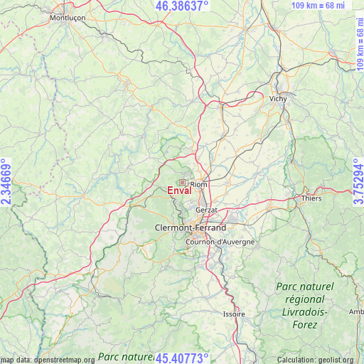
Enval GPS coordinates[2]
45° 53' 57.156" North, 3° 2' 59.316" East
| Map corner | latitude | longitude |
|---|---|---|
| Upper-left | 46.38637°, | 2.34669° |
| Center: | 45.89921°, | 3.04981° |
| Lower-right: | 45.40773°, | 3.75294° |
| Map W x H: | 108.8×108.8 km | = 67.6×67.6mi |
| max Lat: | 51.07786° ⇑67.6% North |
| Enval: | 45.89921° |
| min Lat: | ⇓32.4% South 41.3874° |
| min Long | Enval | max Long |
| -5.08615° | 3.04981° | 9.52242° |
| W 58.5%⇐ | ⇒41.5% E |
Elevation
Elevation of Enval is 445 m = 1460 ft, and this is 251.3 m = 824 ft above average elevation for this country.
| Max E: |
2333 m = 7654 ft | 9.2% |
| Enval | 445 m 1460 ft | |
| Avg. | 193.7 m = 635 ft | |
Min E: |
-1 m = -3 ft | 90.8% |
See also: France elevation on elevation.city.
Geographical zone
Enval is located in North temperate zone (between Tropic of Cancer and the Arctic Circle). Distance of this North polar circle is 2297.7 km =1427.7 mi to North.| Distance of | km | miles | from Enval |
|---|---|---|---|
| North Pole | 4903.5 | 3046.9 | to North |
| Arctic Circle | 2297.7 | 1427.7 | to North |
| Tropic Cancer | 2497.6 | 1551.9 | to South |
| Equator | 5103.5 | 3171.2 | to South |


Nearby cities:
15 places around Enval: (largest is in red/bold)
• Blanzat
8 km =5 mi,  164°
164°
• Chanat-la-Mouteyre
8.1 km =5 mi,  199°
199°
• Charbonnières-les-Varennes
4 km =2.5 mi,  283°
283°
• Châteaugay
6 km =3.7 mi,  153°
153°
• Châtel-Guyon
2.8 km =1.7 mi,  23°
23°
• Davayat
7 km =4.3 mi,  40°
40°
• Loubeyrat
5.1 km =3.2 mi,  323°
323°
• Malauzat
5.8 km =3.6 mi,  177°
177°
• Marsat
3.5 km =2.2 mi,  135°
135°
• Mozac
3.6 km =2.2 mi,  99°
99°
• Ménétrol
6.5 km =4 mi,  118°
118°
• Riom
4.9 km =3 mi, 97°
• Saint-Bonnet-près-Riom
6 km =3.7 mi,  55°
55°
• Sayat
8.1 km =5 mi, 178°
• Volvic
3.2 km =2 mi, 196°
Sources, notices
• [Note1] Compared only with cities in France existing in our database
• [Src1] Map data: © OpenStreetMap contributors (CC-BY-SA)
• [Src2] Other city data from geonames.org with taken over terms of usage.
• [Src3] Geographical zone / Annual Mean Temperature by Robert A. Rohde @ Wikipedia
