Marigné geodata
Marigné (Pays de la Loire) is a populated place; located in France in Europe/Paris (GMT+2) time zone. With population of 554 people, there are 14131 cities with bigger population in this country. Compared to other cities in France, 54.6% of cities are located further ↓South; 84.7% of cities are located further →East and 80.6% of cities have higher elevation than Marigné. Note1
Administrative division(s):
- Level 1: Pays de la Loire
- Level 2: Département de Maine-et-Loire
- Level 3: Arrondissement de Segré
- Level 4: Les Hauts-d'Anjou


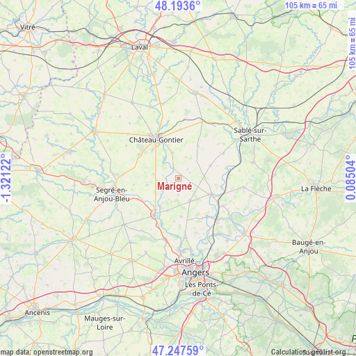
Marigné GPS coordinates[2]
47° 43' 21.864" North, 0° 37' 5.124" West
| Map corner | latitude | longitude |
|---|---|---|
| Upper-left | 48.1936°, | -1.32122° |
| Center: | 47.72274°, | -0.61809° |
| Lower-right: | 47.24759°, | 0.08504° |
| Map W x H: | 105.2×105.2 km | = 65.4×65.4mi |
| max Lat: | 51.07786° ⇑45.4% North |
| Marigné: | 47.72274° |
| min Lat: | ⇓54.6% South 41.3874° |
| min Long | Marigné | max Long |
| -5.08615° | -0.61809° | 9.52242° |
| W 15.3%⇐ | ⇒84.7% E |
Elevation
Elevation of Marigné is 53 m = 174 ft, and this is 140.7 m = 462 ft below average elevation for this country.
| Max E: |
2333 m = 7654 ft | 80.6% |
| Avg. | 193.7 m = 635 ft | |
| Marigné | 53 m = 174 ft | |
Min E: |
-1 m = -3 ft | 19.4% |
See also: France elevation on elevation.city.
Geographical zone
Marigné is located in North temperate zone (between Tropic of Cancer and the Arctic Circle). Distance of this North polar circle is 2094.9 km =1301.7 mi to North.| Distance of | km | miles | from Marigné |
|---|---|---|---|
| North Pole | 4700.8 | 2920.9 | to North |
| Arctic Circle | 2094.9 | 1301.7 | to North |
| Tropic Cancer | 2700.4 | 1678 | to South |
| Equator | 5306.3 | 3297.2 | to South |


Nearby cities:
15 places around Marigné: (largest is in red/bold)
• Azé
12.1 km =7.5 mi,  336°
336°
• Bierné
11.3 km =7 mi,  29°
29°
• Brissarthe
12.9 km =8 mi,  101°
101°
• Champigné
7.5 km =4.7 mi,  152°
152°
• Chemazé
13.7 km =8.5 mi,  301°
301°
• Château-Gontier
13.4 km =8.3 mi,  331°
331°
• Châteauneuf-sur-Sarthe
10.9 km =6.8 mi,  115°
115°
• Contigné
7.6 km =4.7 mi,  84°
84°
• Coudray
7.8 km =4.8 mi,  345°
345°
• Juvardeil
11.8 km =7.3 mi,  130°
130°
• Miré
10.2 km =6.3 mi,  67°
67°
• Montreuil-sur-Maine
10.1 km =6.3 mi,  216°
216°
• Ménil
7.5 km =4.7 mi,  323°
323°
• Saint-Fort
11.5 km =7.1 mi, 317°
• Saint-Martin-du-Bois
9.5 km =5.9 mi,  259°
259°
Sources, notices
• [Note1] Compared only with cities in France existing in our database
• [Src1] Map data: © OpenStreetMap contributors (CC-BY-SA)
• [Src2] Other city data from geonames.org with taken over terms of usage.
• [Src3] Geographical zone / Annual Mean Temperature by Robert A. Rohde @ Wikipedia
