Coudray geodata
Coudray (Pays de la Loire) is a populated place; located in France in Europe/Paris (GMT+2) time zone. With population of 670 people, there are 12215 cities with bigger population in this country. Compared to other cities in France, 55.6% of cities are located further ↓South; 85% of cities are located further →East and 74.6% of cities have higher elevation than Coudray. Note1
Administrative division(s):
- Level 1: Pays de la Loire
- Level 2: Mayenne
- Level 3: Arrondissement de Château-Gontier
- Level 4: Coudray


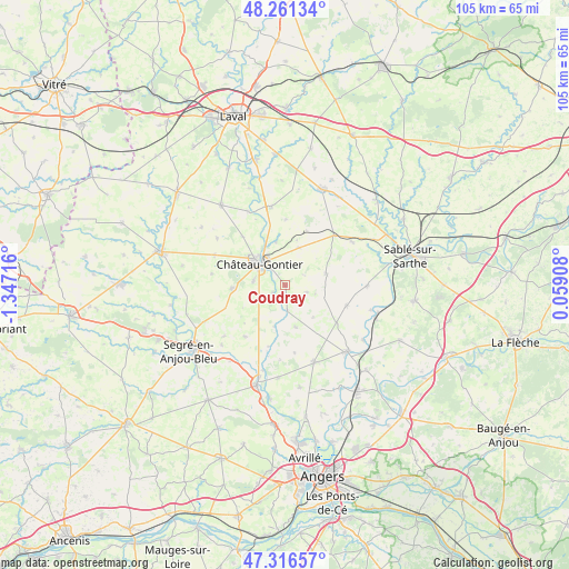
Coudray GPS coordinates[2]
47° 47' 27.96" North, 0° 38' 38.544" West
| Map corner | latitude | longitude |
|---|---|---|
| Upper-left | 48.26134°, | -1.34716° |
| Center: | 47.7911°, | -0.64404° |
| Lower-right: | 47.31657°, | 0.05908° |
| Map W x H: | 105×105 km | = 65.2×65.2mi |
| max Lat: | 51.07786° ⇑44.4% North |
| Coudray: | 47.7911° |
| min Lat: | ⇓55.6% South 41.3874° |
| min Long | Coudray | max Long |
| -5.08615° | -0.64404° | 9.52242° |
| W 15%⇐ | ⇒85% E |
Elevation
Elevation of Coudray is 68 m = 223 ft, and this is 125.7 m = 412 ft below average elevation for this country.
| Max E: |
2333 m = 7654 ft | 74.6% |
| Avg. | 193.7 m = 635 ft | |
| Coudray | 68 m = 223 ft | |
Min E: |
-1 m = -3 ft | 25.4% |
See also: France elevation on elevation.city.
Geographical zone
Coudray is located in North temperate zone (between Tropic of Cancer and the Arctic Circle). Distance of this North polar circle is 2087.3 km =1297 mi to North.| Distance of | km | miles | from Coudray |
|---|---|---|---|
| North Pole | 4693.2 | 2916.2 | to North |
| Arctic Circle | 2087.3 | 1297 | to North |
| Tropic Cancer | 2708 | 1682.7 | to South |
| Equator | 5313.9 | 3301.9 | to South |


Nearby cities:
15 places around Coudray: (largest is in red/bold)
• Azé
4.5 km =2.8 mi,  319°
319°
• Bierné
7.8 km =4.8 mi,  73°
73°
• Chemazé
9.8 km =6.1 mi,  267°
267°
• Château-Gontier
6.1 km =3.8 mi,  313°
313°
• Contigné
11.7 km =7.3 mi,  125°
125°
• Fromentières
8.3 km =5.2 mi,  348°
348°
• Gennes-sur-Glaize
7.4 km =4.6 mi,  21°
21°
• Grez-en-Bouère
12.9 km =8 mi,  44°
44°
• Laigné
14.2 km =8.8 mi,  293°
293°
• Loigné-sur-Mayenne
12 km =7.5 mi, 319°
• Marigné
7.8 km =4.8 mi,  165°
165°
• Miré
12 km =7.5 mi,  108°
108°
• Ménil
2.9 km =1.8 mi,  237°
237°
• Saint-Fort
5.8 km =3.6 mi,  278°
278°
• Saint-Martin-du-Bois
11.9 km =7.4 mi,  218°
218°
Sources, notices
• [Note1] Compared only with cities in France existing in our database
• [Src1] Map data: © OpenStreetMap contributors (CC-BY-SA)
• [Src2] Other city data from geonames.org with taken over terms of usage.
• [Src3] Geographical zone / Annual Mean Temperature by Robert A. Rohde @ Wikipedia
