Saint-Fort geodata
Saint-Fort (Pays de la Loire) is a populated place; located in France in Europe/Paris (GMT+2) time zone. With population of 1,655 people, there are 5649 cities with bigger population in this country. Compared to other cities in France, 55.7% of cities are located further ↓South; 85.8% of cities are located further →East and 75% of cities have higher elevation than Saint-Fort. Note1
Administrative division(s):
- Level 1: Pays de la Loire
- Level 2: Mayenne
- Level 3: Arrondissement de Château-Gontier
- Level 4: Château-Gontier-sur-Mayenne


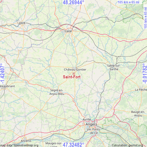
Saint-Fort GPS coordinates[2]
47° 47' 57.408" North, 0° 43' 15.42" West
| Map corner | latitude | longitude |
|---|---|---|
| Upper-left | 48.26944°, | -1.42407° |
| Center: | 47.79928°, | -0.72095° |
| Lower-right: | 47.32482°, | -0.01782° |
| Map W x H: | 105×105 km | = 65.2×65.2mi |
| max Lat: | 51.07786° ⇑44.3% North |
| Saint-Fort: | 47.79928° |
| min Lat: | ⇓55.7% South 41.3874° |
| min Long | Saint-Fort | max Long |
| -5.08615° | -0.72095° | 9.52242° |
| W 14.2%⇐ | ⇒85.8% E |
Elevation
Elevation of Saint-Fort is 67 m = 220 ft, and this is 126.7 m = 416 ft below average elevation for this country.
| Max E: |
2333 m = 7654 ft | 75% |
| Avg. | 193.7 m = 635 ft | |
| Saint-Fort | 67 m = 220 ft | |
Min E: |
-1 m = -3 ft | 25% |
See also: France elevation on elevation.city.
Geographical zone
Saint-Fort is located in North temperate zone (between Tropic of Cancer and the Arctic Circle). Distance of this North polar circle is 2086.4 km =1296.4 mi to North.| Distance of | km | miles | from Saint-Fort |
|---|---|---|---|
| North Pole | 4692.3 | 2915.7 | to North |
| Arctic Circle | 2086.4 | 1296.4 | to North |
| Tropic Cancer | 2708.9 | 1683.2 | to South |
| Equator | 5314.8 | 3302.5 | to South |


Nearby cities:
15 places around Saint-Fort: (largest is in red/bold)
• Azé
3.8 km =2.4 mi,  47°
47°
• Bierné
13.3 km =8.3 mi,  84°
84°
• Chemazé
4.3 km =2.7 mi,  251°
251°
• Château-Gontier
3.5 km =2.2 mi,  22°
22°
• Coudray
5.8 km =3.6 mi,  98°
98°
• Fromentières
8.3 km =5.2 mi,  29°
29°
• Gennes-sur-Glaize
10.4 km =6.5 mi, 54°
• Laigné
8.7 km =5.4 mi,  303°
303°
• Loigné-sur-Mayenne
8.4 km =5.2 mi,  345°
345°
• Marigné
11.5 km =7.1 mi,  137°
137°
• Marigné-Peuton
10.4 km =6.5 mi,  318°
318°
• Ménil
4.1 km =2.5 mi,  127°
127°
• Pommerieux
13.5 km =8.4 mi,  281°
281°
• Saint-Martin-du-Bois
10.4 km =6.5 mi,  188°
188°
• Villiers-Charlemagne
14 km =8.7 mi,  13°
13°
Sources, notices
• [Note1] Compared only with cities in France existing in our database
• [Src1] Map data: © OpenStreetMap contributors (CC-BY-SA)
• [Src2] Other city data from geonames.org with taken over terms of usage.
• [Src3] Geographical zone / Annual Mean Temperature by Robert A. Rohde @ Wikipedia
