Meung-sur-Loire geodata
Meung-sur-Loire (Centre) is a populated place; located in France in Europe/Paris (GMT+2) time zone. With population of 6,659 people, there are 1484 cities with bigger population in this country. Compared to other cities in France, 56.3% of cities are located further ↓South; 60.5% of cities are located further →East and 63.6% of cities have higher elevation than Meung-sur-Loire. Note1
Administrative division(s):
- Level 1: Centre
- Level 2: Loiret
- Level 3: Arrondissement d’Orléans
- Level 4: Meung-sur-Loire


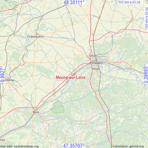
Meung-sur-Loire GPS coordinates[2]
47° 49' 52.464" North, 1° 41' 44.952" East
| Map corner | latitude | longitude |
|---|---|---|
| Upper-left | 48.30111°, | 0.9927° |
| Center: | 47.83124°, | 1.69582° |
| Lower-right: | 47.35707°, | 2.39895° |
| Map W x H: | 105×105 km | = 65.2×65.2mi |
| max Lat: | 51.07786° ⇑43.7% North |
| Meung-sur-Loire: | 47.83124° |
| min Lat: | ⇓56.3% South 41.3874° |
| min Long | Meung-sur-Loire | max Long |
| -5.08615° | 1.69582° | 9.52242° |
| W 39.5%⇐ | ⇒60.5% E |
Elevation
Elevation of Meung-sur-Loire is 93 m = 305 ft, and this is 100.7 m = 330 ft below average elevation for this country.
| Max E: |
2333 m = 7654 ft | 63.6% |
| Avg. | 193.7 m = 635 ft | |
| Meung-sur-Loire | 93 m = 305 ft | |
Min E: |
-1 m = -3 ft | 36.4% |
See also: France elevation on elevation.city.
Geographical zone
Meung-sur-Loire is located in North temperate zone (between Tropic of Cancer and the Arctic Circle). Distance of this North polar circle is 2082.8 km =1294.2 mi to North.| Distance of | km | miles | from Meung-sur-Loire |
|---|---|---|---|
| North Pole | 4688.7 | 2913.4 | to North |
| Arctic Circle | 2082.8 | 1294.2 | to North |
| Tropic Cancer | 2712.4 | 1685.4 | to South |
| Equator | 5318.3 | 3304.6 | to South |


Nearby cities:
15 places around Meung-sur-Loire: (largest is in red/bold)
• Baccon
8.4 km =5.2 mi,  323°
323°
• Baule
2.9 km =1.8 mi,  217°
217°
• Beaugency
7.7 km =4.8 mi, 222°
• Chaingy
8 km =5 mi,  43°
43°
• Cléry-Saint-André
4.2 km =2.6 mi,  103°
103°
• Cravant
9.3 km =5.8 mi,  268°
268°
• Dry
4.1 km =2.5 mi,  161°
161°
• Huisseau-sur-Mauves
6.9 km =4.3 mi,  4°
4°
• Lailly-en-Val
6.9 km =4.3 mi,  185°
185°
• Le Bardon
3.6 km =2.2 mi,  295°
295°
• Mareau-aux-Prés
7.6 km =4.7 mi,  58°
58°
• Messas
5.2 km =3.2 mi,  238°
238°
• Mézières-lez-Cléry
8.2 km =5.1 mi, 101°
• Saint-Ay
5.2 km =3.2 mi,  53°
53°
• Villorceau
8.1 km =5 mi,  245°
245°
Sources, notices
• [Note1] Compared only with cities in France existing in our database
• [Src1] Map data: © OpenStreetMap contributors (CC-BY-SA)
• [Src2] Other city data from geonames.org with taken over terms of usage.
• [Src3] Geographical zone / Annual Mean Temperature by Robert A. Rohde @ Wikipedia
