Huisseau-sur-Mauves geodata
Huisseau-sur-Mauves (Centre) is a populated place; located in France in Europe/Paris (GMT+2) time zone. With population of 1,744 people, there are 5429 cities with bigger population in this country. Compared to other cities in France, 57.4% of cities are located further ↓South; 60.4% of cities are located further →East and 59.1% of cities have higher elevation than Huisseau-sur-Mauves. Note1
Administrative division(s):
- Level 1: Centre
- Level 2: Loiret
- Level 3: Arrondissement d’Orléans
- Level 4: Huisseau-sur-Mauves


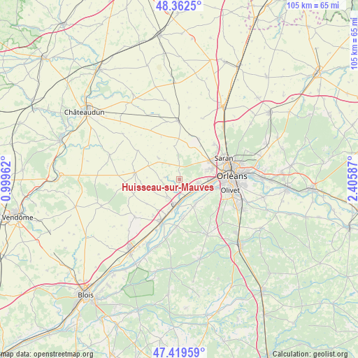
Huisseau-sur-Mauves GPS coordinates[2]
47° 53' 35.484" North, 1° 42' 9.864" East
| Map corner | latitude | longitude |
|---|---|---|
| Upper-left | 48.3625°, | 0.99962° |
| Center: | 47.89319°, | 1.70274° |
| Lower-right: | 47.41959°, | 2.40587° |
| Map W x H: | 104.8×104.8 km | = 65.1×65.1mi |
| max Lat: | 51.07786° ⇑42.6% North |
| Huisseau-sur-Mauves: | 47.89319° |
| min Lat: | ⇓57.4% South 41.3874° |
| min Long | Huisseau-sur-Ma | max Long |
| -5.08615° | 1.70274° | 9.52242° |
| W 39.6%⇐ | ⇒60.4% E |
Elevation
Elevation of Huisseau-sur-Mauves is 105 m = 344 ft, and this is 88.7 m = 291 ft below average elevation for this country.
| Max E: |
2333 m = 7654 ft | 59.1% |
| Avg. | 193.7 m = 635 ft | |
| Huisseau-sur-Mauves | 105 m = 344 ft | |
Min E: |
-1 m = -3 ft | 40.9% |
See also: France elevation on elevation.city.
Geographical zone
Huisseau-sur-Mauves is located in North temperate zone (between Tropic of Cancer and the Arctic Circle). Distance of this North polar circle is 2076 km =1290 mi to North.| Distance of | km | miles | from Huisseau-sur-Mauves |
|---|---|---|---|
| North Pole | 4681.8 | 2909.1 | to North |
| Arctic Circle | 2076 | 1290 | to North |
| Tropic Cancer | 2719.3 | 1689.7 | to South |
| Equator | 5325.2 | 3308.9 | to South |


Nearby cities:
15 places around Huisseau-sur-Mauves: (largest is in red/bold)
• Baccon
5.5 km =3.4 mi,  267°
267°
• Baule
9.4 km =5.8 mi,  193°
193°
• Chaingy
5.2 km =3.2 mi,  102°
102°
• Charsonville
10 km =6.2 mi,  292°
292°
• Cléry-Saint-André
8.7 km =5.4 mi,  155°
155°
• Coulmiers
5.1 km =3.2 mi,  326°
326°
• Ingré
9.8 km =6.1 mi,  72°
72°
• La Chapelle-Saint-Mesmin
9.9 km =6.2 mi,  94°
94°
• Le Bardon
6.6 km =4.1 mi,  215°
215°
• Mareau-aux-Prés
6.7 km =4.2 mi,  116°
116°
• Meung-sur-Loire
6.9 km =4.3 mi,  184°
184°
• Ormes
10.1 km =6.3 mi,  58°
58°
• Saint-Ay
5.3 km =3.3 mi,  136°
136°
• Saint-Hilaire-Saint-Mesmin
10.2 km =6.3 mi,  107°
107°
• Épieds-en-Beauce
9 km =5.6 mi,  315°
315°
Sources, notices
• [Note1] Compared only with cities in France existing in our database
• [Src1] Map data: © OpenStreetMap contributors (CC-BY-SA)
• [Src2] Other city data from geonames.org with taken over terms of usage.
• [Src3] Geographical zone / Annual Mean Temperature by Robert A. Rohde @ Wikipedia
