Mantilly geodata
Mantilly (Normandy) is a populated place; located in France in Europe/Paris (GMT+2) time zone. With population of 647 people, there are 12562 cities with bigger population in this country. Compared to other cities in France, 68.9% of cities are located further ↓South; 86.4% of cities are located further →East and 64.4% of cities have lower elevation than Mantilly. Note1
Administrative division(s):
- Level 1: Normandy
- Level 2: Département de l'Orne
- Level 3: Arrondissement d’Alençon
- Level 4: Mantilly


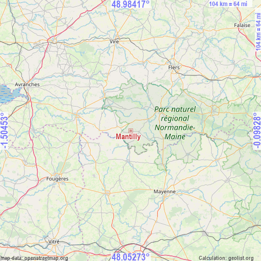
Mantilly GPS coordinates[2]
48° 31' 14.124" North, 0° 48' 5.04" West
| Map corner | latitude | longitude |
|---|---|---|
| Upper-left | 48.98417°, | -1.50453° |
| Center: | 48.52059°, | -0.8014° |
| Lower-right: | 48.05273°, | -0.09828° |
| Map W x H: | 103.6×103.6 km | = 64.4×64.4mi |
| max Lat: | 51.07786° ⇑31.1% North |
| Mantilly: | 48.52059° |
| min Lat: | ⇓68.9% South 41.3874° |
| min Long | Mantilly | max Long |
| -5.08615° | -0.8014° | 9.52242° |
| W 13.6%⇐ | ⇒86.4% E |
Elevation
Elevation of Mantilly is 191 m = 627 ft, and this is 2.7 m = 9 ft below average elevation for this country.
| Max E: |
2333 m = 7654 ft | 35.6% |
| Avg. | 193.7 m = 635 ft | |
| Mantilly | 191 m = 627 ft | |
Min E: |
-1 m = -3 ft | 64.4% |
See also: France elevation on elevation.city.
Geographical zone
Mantilly is located in North temperate zone (between Tropic of Cancer and the Arctic Circle). Distance of this North polar circle is 2006.2 km =1246.6 mi to North.| Distance of | km | miles | from Mantilly |
|---|---|---|---|
| North Pole | 4612.1 | 2865.8 | to North |
| Arctic Circle | 2006.2 | 1246.6 | to North |
| Tropic Cancer | 2789.1 | 1733.1 | to South |
| Equator | 5395 | 3352.3 | to South |


Nearby cities:
15 places around Mantilly: (largest is in red/bold)
• Barenton
9.2 km =5.7 mi,  345°
345°
• Brecé
13.4 km =8.3 mi,  179°
179°
• Buais
12.4 km =7.7 mi,  271°
271°
• Ceaucé
13.3 km =8.3 mi,  102°
102°
• Domfront
13.9 km =8.6 mi,  55°
55°
• Désertines
7.5 km =4.7 mi,  220°
220°
• Fougerolles-du-Plessis
13.6 km =8.5 mi,  247°
247°
• Gorron
12.2 km =7.6 mi, 183°
• La Haute-Chapelle
13.5 km =8.4 mi,  45°
45°
• Le Pas
12.6 km =7.8 mi,  143°
143°
• Le Teilleul
5.6 km =3.5 mi,  289°
289°
• Notre-Dame-du-Touchet
13.4 km =8.3 mi,  301°
301°
• Passais
2.6 km =1.6 mi, 99°
• Saint-Fraimbault
8.5 km =5.3 mi,  119°
119°
• Saint-Georges-de-Rouelley
9.5 km =5.9 mi,  14°
14°
Sources, notices
• [Note1] Compared only with cities in France existing in our database
• [Src1] Map data: © OpenStreetMap contributors (CC-BY-SA)
• [Src2] Other city data from geonames.org with taken over terms of usage.
• [Src3] Geographical zone / Annual Mean Temperature by Robert A. Rohde @ Wikipedia
