Buais geodata
Buais (Normandy) is a populated place; located in France in Europe/Paris (GMT+2) time zone. With population of 626 people, there are 12883 cities with bigger population in this country. Compared to other cities in France, 68.9% of cities are located further ↓South; 87.9% of cities are located further →East and 72.5% of cities have lower elevation than Buais. Note1
Administrative division(s):
- Level 1: Normandy
- Level 2: Manche
- Level 3: Avranches
- Level 4: Buais-Les-Monts


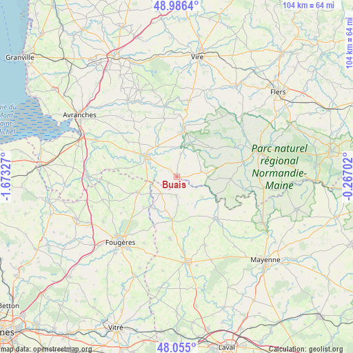
Buais GPS coordinates[2]
48° 31' 22.224" North, 0° 58' 12.54" West
| Map corner | latitude | longitude |
|---|---|---|
| Upper-left | 48.9864°, | -1.67327° |
| Center: | 48.52284°, | -0.97015° |
| Lower-right: | 48.055°, | -0.26702° |
| Map W x H: | 103.6×103.6 km | = 64.4×64.4mi |
| max Lat: | 51.07786° ⇑31.1% North |
| Buais: | 48.52284° |
| min Lat: | ⇓68.9% South 41.3874° |
| min Long | Buais | max Long |
| -5.08615° | -0.97015° | 9.52242° |
| W 12.1%⇐ | ⇒87.9% E |
Elevation
Elevation of Buais is 233 m = 764 ft, and this is 39.3 m = 129 ft above average elevation for this country.
| Max E: |
2333 m = 7654 ft | 27.5% |
| Buais | 233 m 764 ft | |
| Avg. | 193.7 m = 635 ft | |
Min E: |
-1 m = -3 ft | 72.5% |
See also: France elevation on elevation.city.
Geographical zone
Buais is located in North temperate zone (between Tropic of Cancer and the Arctic Circle). Distance of this North polar circle is 2005.9 km =1246.4 mi to North.| Distance of | km | miles | from Buais |
|---|---|---|---|
| North Pole | 4611.8 | 2865.6 | to North |
| Arctic Circle | 2005.9 | 1246.4 | to North |
| Tropic Cancer | 2789.3 | 1733.2 | to South |
| Equator | 5395.2 | 3352.4 | to South |


Nearby cities:
15 places around Buais: (largest is in red/bold)
• Barenton
13.3 km =8.3 mi,  49°
49°
• Désertines
9.7 km =6 mi,  128°
128°
• Fougerolles-du-Plessis
5.4 km =3.4 mi,  181°
181°
• Landivy
6.8 km =4.2 mi,  223°
223°
• Le Teilleul
7.3 km =4.5 mi,  77°
77°
• Les Loges-Marchis
8.9 km =5.5 mi,  283°
283°
• Louvigné-du-Désert
12.4 km =7.7 mi,  247°
247°
• Mantilly
12.4 km =7.7 mi,  91°
91°
• Notre-Dame-du-Touchet
6.7 km =4.2 mi,  8°
8°
• Parigny
11.3 km =7 mi,  314°
314°
• Pontmain
11.5 km =7.1 mi, 216°
• Romagny
13 km =8.1 mi,  1°
1°
• Saint-Hilaire-du-Harcouët
10.7 km =6.6 mi,  304°
304°
• Saint-Mars-sur-la-Futaie
10.7 km =6.6 mi,  198°
198°
• Savigny-le-Vieux
5.8 km =3.6 mi,  267°
267°
Sources, notices
• [Note1] Compared only with cities in France existing in our database
• [Src1] Map data: © OpenStreetMap contributors (CC-BY-SA)
• [Src2] Other city data from geonames.org with taken over terms of usage.
• [Src3] Geographical zone / Annual Mean Temperature by Robert A. Rohde @ Wikipedia
