La Haute-Chapelle geodata
La Haute-Chapelle (Normandy) is a populated place; located in France in Europe/Paris (GMT+2) time zone. With population of 614 people, there are 13088 cities with bigger population in this country. Compared to other cities in France, 71% of cities are located further ↓South; 85.2% of cities are located further →East and 64.4% of cities have lower elevation than La Haute-Chapelle. Note1
Administrative division(s):
- Level 1: Normandy
- Level 2: Département de l'Orne
- Level 3: Argentan
- Level 4: Domfront en Poiraie


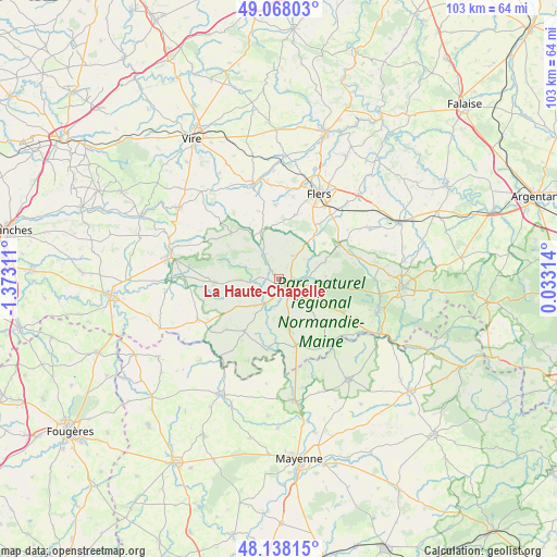
La Haute-Chapelle GPS coordinates[2]
48° 36' 18.828" North, 0° 40' 11.928" West
| Map corner | latitude | longitude |
|---|---|---|
| Upper-left | 49.06803°, | -1.37311° |
| Center: | 48.60523°, | -0.66998° |
| Lower-right: | 48.13815°, | 0.03314° |
| Map W x H: | 103.4×103.4 km | = 64.2×64.2mi |
| max Lat: | 51.07786° ⇑29% North |
| La Haute-Chapelle: | 48.60523° |
| min Lat: | ⇓71% South 41.3874° |
| min Long | La Haute-Chapel | max Long |
| -5.08615° | -0.66998° | 9.52242° |
| W 14.8%⇐ | ⇒85.2% E |
Elevation
Elevation of La Haute-Chapelle is 191 m = 627 ft, and this is 2.7 m = 9 ft below average elevation for this country.
| Max E: |
2333 m = 7654 ft | 35.6% |
| Avg. | 193.7 m = 635 ft | |
| La Haute-Chapelle | 191 m = 627 ft | |
Min E: |
-1 m = -3 ft | 64.4% |
See also: France elevation on elevation.city.
Geographical zone
La Haute-Chapelle is located in North temperate zone (between Tropic of Cancer and the Arctic Circle). Distance of this North polar circle is 1996.8 km =1240.8 mi to North.| Distance of | km | miles | from La Haute-Chapelle |
|---|---|---|---|
| North Pole | 4602.7 | 2860 | to North |
| Arctic Circle | 1996.8 | 1240.8 | to North |
| Tropic Cancer | 2798.5 | 1738.9 | to South |
| Equator | 5404.4 | 3358.1 | to South |


Nearby cities:
15 places around La Haute-Chapelle: (largest is in red/bold)
• Barenton
12 km =7.5 mi,  267°
267°
• Ceaucé
12.8 km =8 mi,  165°
165°
• Champsecret
8.8 km =5.5 mi,  87°
87°
• Domfront
2.3 km =1.4 mi,  129°
129°
• Ger
12.1 km =7.5 mi,  314°
314°
• Juvigny-sous-Andaine
13.3 km =8.3 mi,  116°
116°
• La Chapelle-au-Moine
13.1 km =8.1 mi,  29°
29°
• La Ferrière-aux-Étangs
12.7 km =7.9 mi,  60°
60°
• Mantilly
13.5 km =8.4 mi,  225°
225°
• Passais
12.1 km =7.5 mi,  215°
215°
• Saint-Bômer-les-Forges
5.1 km =3.2 mi, 32°
• Saint-Clair-de-Halouze
8.8 km =5.5 mi,  20°
20°
• Saint-Cornier-des-Landes
13 km =8.1 mi,  343°
343°
• Saint-Fraimbault
13.7 km =8.5 mi,  189°
189°
• Saint-Georges-de-Rouelley
7.2 km =4.5 mi, 268°
Sources, notices
• [Note1] Compared only with cities in France existing in our database
• [Src1] Map data: © OpenStreetMap contributors (CC-BY-SA)
• [Src2] Other city data from geonames.org with taken over terms of usage.
• [Src3] Geographical zone / Annual Mean Temperature by Robert A. Rohde @ Wikipedia
