Saint-Georges-de-Rouelley geodata
Saint-Georges-de-Rouelley (Normandy) is a populated place; located in France in Europe/Paris (GMT+2) time zone. With population of 528 people, there are 14653 cities with bigger population in this country. Compared to other cities in France, 70.9% of cities are located further ↓South; 86.2% of cities are located further →East and 56.1% of cities have lower elevation than Saint-Georges-de-Rouelley. Note1
Administrative division(s):
- Level 1: Normandy
- Level 2: Manche
- Level 3: Avranches
- Level 4: Saint-Georges-de-Rouelley
Current local time in Saint-Georges-de-Rouelley:
09:32 PM, SaturdayDifference from your time zone: hours


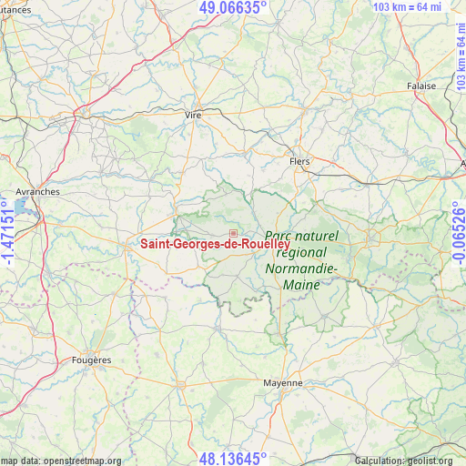
Saint-Georges-de-Rouelley GPS coordinates[2]
48° 36' 12.744" North, 0° 46' 6.168" West
| Map corner | latitude | longitude |
|---|---|---|
| Upper-left | 49.06635°, | -1.47151° |
| Center: | 48.60354°, | -0.76838° |
| Lower-right: | 48.13645°, | -0.06526° |
| Map W x H: | 103.4×103.4 km | = 64.2×64.2mi |
| max Lat: | 51.07786° ⇑29.1% North |
| Saint-Georges-de-Rouelley: | 48.60354° |
| min Lat: | ⇓70.9% South 41.3874° |
| min Long | Saint-Georges-d | max Long |
| -5.08615° | -0.76838° | 9.52242° |
| W 13.8%⇐ | ⇒86.2% E |
Elevation
Elevation of Saint-Georges-de-Rouelley is 154 m = 505 ft, and this is 39.7 m = 130 ft below average elevation for this country.
| Max E: |
2333 m = 7654 ft | 43.9% |
| Avg. | 193.7 m = 635 ft | |
| Saint-Georges-de-Rouelley | 154 m = 505 ft | |
Min E: |
-1 m = -3 ft | 56.1% |
See also: France elevation on elevation.city.
Geographical zone
Saint-Georges-de-Rouelley is located in North temperate zone (between Tropic of Cancer and the Arctic Circle). Distance of this North polar circle is 1997 km =1240.9 mi to North.| Distance of | km | miles | from Saint-Georges-de-Rouelley |
|---|---|---|---|
| North Pole | 4602.9 | 2860.1 | to North |
| Arctic Circle | 1997 | 1240.9 | to North |
| Tropic Cancer | 2798.3 | 1738.8 | to South |
| Equator | 5404.2 | 3358 | to South |


Nearby cities:
15 places around Saint-Georges-de-Rouelley: (largest is in red/bold)
• Barenton
4.7 km =2.9 mi,  265°
265°
• Domfront
9.1 km =5.7 mi,  98°
98°
• Ger
8.8 km =5.5 mi,  350°
350°
• La Haute-Chapelle
7.2 km =4.5 mi,  88°
88°
• Le Neufbourg
14.4 km =8.9 mi,  293°
293°
• Le Teilleul
10.6 km =6.6 mi,  226°
226°
• Mantilly
9.5 km =5.9 mi,  194°
194°
• Mortain
13.6 km =8.5 mi, 291°
• Notre-Dame-du-Touchet
14 km =8.7 mi,  260°
260°
• Passais
9.7 km =6 mi,  179°
179°
• Saint-Bômer-les-Forges
10.9 km =6.8 mi,  65°
65°
• Saint-Clair-de-Halouze
13.3 km =8.3 mi,  50°
50°
• Saint-Clément-Rancoudray
11 km =6.8 mi,  309°
309°
• Saint-Cornier-des-Landes
13.1 km =8.1 mi,  15°
15°
• Saint-Fraimbault
14.3 km =8.9 mi,  159°
159°
Sources, notices
• [Note1] Compared only with cities in France existing in our database
• [Src1] Map data: © OpenStreetMap contributors (CC-BY-SA)
• [Src2] Other city data from geonames.org with taken over terms of usage.
• [Src3] Geographical zone / Annual Mean Temperature by Robert A. Rohde @ Wikipedia
