Entremont geodata
Entremont (Auvergne-Rhône-Alpes) is a populated place; located in France in Europe/Paris (GMT+2) time zone. With population of 549 people, there are 14229 cities with bigger population in this country. Compared to other cities in France, 66.8% of cities are located further ↑North; 91% of cities are located further ←West and 97.6% of cities have lower elevation than Entremont. Note1
Administrative division(s):
- Level 1: Auvergne-Rhône-Alpes
- Level 2: Haute-Savoie
- Level 3: Arrondissement de Bonneville
- Level 4: Glières-Val-de-Borne


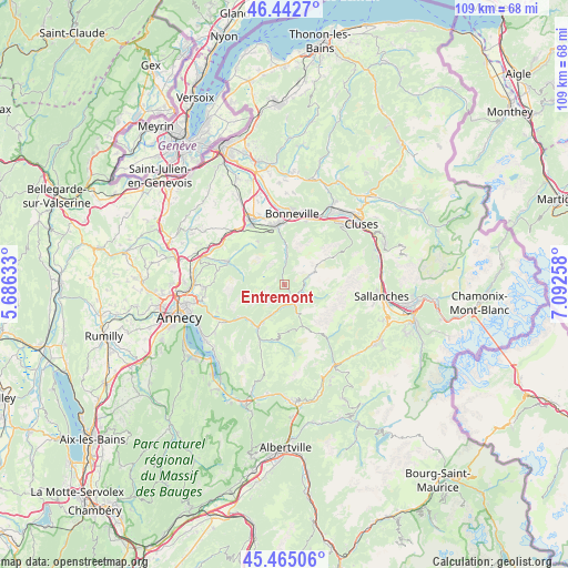
Entremont GPS coordinates[2]
45° 57' 21.744" North, 6° 23' 22.056" East
| Map corner | latitude | longitude |
|---|---|---|
| Upper-left | 46.4427°, | 5.68633° |
| Center: | 45.95604°, | 6.38946° |
| Lower-right: | 45.46506°, | 7.09258° |
| Map W x H: | 108.7×108.7 km | = 67.5×67.5mi |
| max Lat: | 51.07786° ⇑66.8% North |
| Entremont: | 45.95604° |
| min Lat: | ⇓33.2% South 41.3874° |
| min Long | Entremont | max Long |
| -5.08615° | 6.38946° | 9.52242° |
| W 91%⇐ | ⇒9% E |
Elevation
Elevation of Entremont is 787 m = 2582 ft, and this is 593.3 m = 1947 ft above average elevation for this country.
| Max E: |
2333 m = 7654 ft | 2.4% |
| Entremont | 787 m 2582 ft | |
| Avg. | 193.7 m = 635 ft | |
Min E: |
-1 m = -3 ft | 97.6% |
See also: France elevation on elevation.city.
Geographical zone
Entremont is located in North temperate zone (between Tropic of Cancer and the Arctic Circle). Distance of this North polar circle is 2291.3 km =1423.7 mi to North.| Distance of | km | miles | from Entremont |
|---|---|---|---|
| North Pole | 4897.2 | 3043 | to North |
| Arctic Circle | 2291.3 | 1423.7 | to North |
| Tropic Cancer | 2503.9 | 1555.9 | to South |
| Equator | 5109.8 | 3175.1 | to South |


Nearby cities:
15 places around Entremont: (largest is in red/bold)
• Aviernoz
12.7 km =7.9 mi,  281°
281°
• Dingy-Saint-Clair
13.8 km =8.6 mi,  246°
246°
• La Clusaz
6.5 km =4 mi,  147°
147°
• La Giettaz
13.1 km =8.1 mi,  141°
141°
• Le Grand-Bornand
3.5 km =2.2 mi,  115°
115°
• Le Petit-Bornand-les-Glières
5 km =3.1 mi,  5°
5°
• Les Clefs
11.5 km =7.1 mi,  203°
203°
• Les Villards-sur-Thônes
4.8 km =3 mi,  193°
193°
• Manigod
10.5 km =6.5 mi, 185°
• Mont-Saxonnex
12.4 km =7.7 mi,  31°
31°
• Saint-Jean-de-Sixt
4 km =2.5 mi, 154°
• Saint-Laurent
10.3 km =6.4 mi,  346°
346°
• Saint-Sixt
11.7 km =7.3 mi,  336°
336°
• Thorens-Glières
11.9 km =7.4 mi,  291°
291°
• Thônes
9.7 km =6 mi,  210°
210°
Sources, notices
• [Note1] Compared only with cities in France existing in our database
• [Src1] Map data: © OpenStreetMap contributors (CC-BY-SA)
• [Src2] Other city data from geonames.org with taken over terms of usage.
• [Src3] Geographical zone / Annual Mean Temperature by Robert A. Rohde @ Wikipedia
