Alleins geodata
Alleins (Provence-Alpes-Côte d'Azur) is a populated place; located in France in Europe/Paris (GMT+2) time zone. With population of 2,176 people, there are 4411 cities with bigger population in this country. Compared to other cities in France, 90.3% of cities are located further ↑North; 79.4% of cities are located further ←West and 58.4% of cities have lower elevation than Alleins. Note1
Administrative division(s):
- Level 1: Provence-Alpes-Côte d'Azur
- Level 2: Département des Bouches-du-Rhône
- Level 3: Aix-en-Provence
- Level 4: Alleins


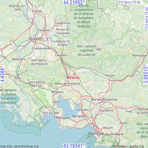
Alleins GPS coordinates[2]
43° 42' 13.932" North, 5° 9' 43.308" East
| Map corner | latitude | longitude |
|---|---|---|
| Upper-left | 44.21002°, | 4.4589° |
| Center: | 43.70387°, | 5.16203° |
| Lower-right: | 43.19341°, | 5.86515° |
| Map W x H: | 113×113 km | = 70.2×70.2mi |
| max Lat: | 51.07786° ⇑90.3% North |
| Alleins: | 43.70387° |
| min Lat: | ⇓9.7% South 41.3874° |
| min Long | Alleins | max Long |
| -5.08615° | 5.16203° | 9.52242° |
| W 79.4%⇐ | ⇒20.6% E |
Elevation
Elevation of Alleins is 163 m = 535 ft, and this is 30.7 m = 101 ft below average elevation for this country.
| Max E: |
2333 m = 7654 ft | 41.6% |
| Avg. | 193.7 m = 635 ft | |
| Alleins | 163 m = 535 ft | |
Min E: |
-1 m = -3 ft | 58.4% |
See also: France elevation on elevation.city.
Geographical zone
Alleins is located in North temperate zone (between Tropic of Cancer and the Arctic Circle). Distance of this Northern Tropic circle is 2253.5 km =1400.3 mi to South.| Distance of | km | miles | from Alleins |
|---|---|---|---|
| North Pole | 5147.6 | 3198.6 | to North |
| Arctic Circle | 2541.8 | 1579.4 | to North |
| Tropic Cancer | 2253.5 | 1400.3 | to South |
| Equator | 4859.4 | 3019.5 | to South |


Nearby cities:
15 places around Alleins: (largest is in red/bold)
• Aurons
4.3 km =2.7 mi,  184°
184°
• Charleval
6.9 km =4.3 mi,  76°
76°
• Eyguières
10.6 km =6.6 mi,  264°
264°
• La Barben
8.3 km =5.2 mi,  171°
171°
• La Roque-d’Anthéron
11.9 km =7.4 mi, 83°
• Lamanon
5.9 km =3.7 mi,  265°
265°
• Lambesc
9.8 km =6.1 mi,  124°
124°
• Lançon-Provence
12.7 km =7.9 mi,  192°
192°
• Mallemort
3.4 km =2.1 mi,  24°
24°
• Mérindol
6.6 km =4.1 mi,  30°
30°
• Puget
10.3 km =6.4 mi,  56°
56°
• Pélissanne
8 km =5 mi, 185°
• Salon-de-Provence
8.7 km =5.4 mi,  218°
218°
• Sénas
8.1 km =5 mi,  303°
303°
• Vernègues
2.2 km =1.4 mi,  159°
159°
Sources, notices
• [Note1] Compared only with cities in France existing in our database
• [Src1] Map data: © OpenStreetMap contributors (CC-BY-SA)
• [Src2] Other city data from geonames.org with taken over terms of usage.
• [Src3] Geographical zone / Annual Mean Temperature by Robert A. Rohde @ Wikipedia
