Saint-Pierre-de-Chandieu geodata
Saint-Pierre-de-Chandieu (Auvergne-Rhône-Alpes) is a populated place; located in France in Europe/Paris (GMT+2) time zone. With population of 4,357 people, there are 2261 cities with bigger population in this country. Compared to other cities in France, 71.8% of cities are located further ↑North; 77.8% of cities are located further ←West and 76.2% of cities have lower elevation than Saint-Pierre-de-Chandieu. Note1
Administrative division(s):
- Level 1: Auvergne-Rhône-Alpes
- Level 2: Département du Rhône
- Level 3: Arrondissement de Lyon
- Level 4: Saint-Pierre-de-Chandieu
Current local time in Saint-Pierre-de-Chandieu:
09:11 AM, WednesdayDifference from your time zone: hours


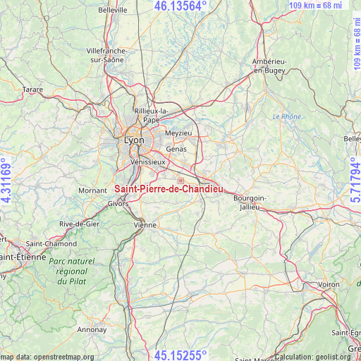
Saint-Pierre-de-Chandieu GPS coordinates[2]
45° 38' 46.5" North, 5° 0' 53.316" East
| Map corner | latitude | longitude |
|---|---|---|
| Upper-left | 46.13564°, | 4.31169° |
| Center: | 45.64625°, | 5.01481° |
| Lower-right: | 45.15255°, | 5.71794° |
| Map W x H: | 109.3×109.3 km | = 67.9×67.9mi |
| max Lat: | 51.07786° ⇑71.8% North |
| Saint-Pierre-de-Chandieu: | 45.64625° |
| min Lat: | ⇓28.2% South 41.3874° |
| min Long | Saint-Pierre-de | max Long |
| -5.08615° | 5.01481° | 9.52242° |
| W 77.8%⇐ | ⇒22.2% E |
Elevation
Elevation of Saint-Pierre-de-Chandieu is 258 m = 846 ft, and this is 64.3 m = 211 ft above average elevation for this country.
| Max E: |
2333 m = 7654 ft | 23.8% |
| Saint-Pierre-de-Chandieu | 258 m 846 ft | |
| Avg. | 193.7 m = 635 ft | |
Min E: |
-1 m = -3 ft | 76.2% |
See also: France elevation on elevation.city.
Geographical zone
Saint-Pierre-de-Chandieu is located in North temperate zone (between Tropic of Cancer and the Arctic Circle). Distance of this North polar circle is 2325.8 km =1445.2 mi to North.| Distance of | km | miles | from Saint-Pierre-de-Chandieu |
|---|---|---|---|
| North Pole | 4931.7 | 3064.4 | to North |
| Arctic Circle | 2325.8 | 1445.2 | to North |
| Tropic Cancer | 2469.5 | 1534.5 | to South |
| Equator | 5075.4 | 3153.7 | to South |


Nearby cities:
15 places around Saint-Pierre-de-Chandieu: (largest is in red/bold)
• Chaponnay
6.5 km =4 mi,  251°
251°
• Corbas
9.1 km =5.7 mi,  285°
285°
• Diémoz
8.4 km =5.2 mi,  136°
136°
• Grenay
5.4 km =3.4 mi,  69°
69°
• Heyrieux
4.1 km =2.5 mi,  113°
113°
• Luzinay
7.6 km =4.7 mi,  214°
214°
• Marennes
8.4 km =5.2 mi, 250°
• Mions
5.2 km =3.2 mi, 291°
• Saint-Bonnet-de-Mure
5 km =3.1 mi,  12°
12°
• Saint-Just-Chaleyssin
5.9 km =3.7 mi,  192°
192°
• Saint-Laurent-de-Mure
5 km =3.1 mi,  28°
28°
• Saint-Priest
7.9 km =4.9 mi,  315°
315°
• Saint-Quentin-Fallavier
7.6 km =4.7 mi,  92°
92°
• Toussieu
2.5 km =1.6 mi, 291°
• Valencin
4.1 km =2.5 mi,  163°
163°
Sources, notices
• [Note1] Compared only with cities in France existing in our database
• [Src1] Map data: © OpenStreetMap contributors (CC-BY-SA)
• [Src2] Other city data from geonames.org with taken over terms of usage.
• [Src3] Geographical zone / Annual Mean Temperature by Robert A. Rohde @ Wikipedia
