Toussieu geodata
Toussieu (Auvergne-Rhône-Alpes) is a populated place; located in France in Europe/Paris (GMT+2) time zone. With population of 2,128 people, there are 4522 cities with bigger population in this country. Compared to other cities in France, 71.6% of cities are located further ↑North; 77.5% of cities are located further ←West and 74% of cities have lower elevation than Toussieu. Note1
Administrative division(s):
- Level 1: Auvergne-Rhône-Alpes
- Level 2: Département du Rhône
- Level 3: Arrondissement de Lyon
- Level 4: Toussieu


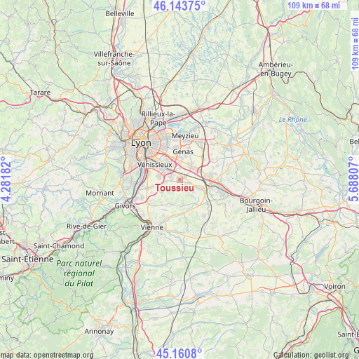
Toussieu GPS coordinates[2]
45° 39' 15.948" North, 4° 59' 5.82" East
| Map corner | latitude | longitude |
|---|---|---|
| Upper-left | 46.14375°, | 4.28182° |
| Center: | 45.65443°, | 4.98495° |
| Lower-right: | 45.1608°, | 5.68807° |
| Map W x H: | 109.3×109.3 km | = 67.9×67.9mi |
| max Lat: | 51.07786° ⇑71.6% North |
| Toussieu: | 45.65443° |
| min Lat: | ⇓28.4% South 41.3874° |
| min Long | Toussieu | max Long |
| -5.08615° | 4.98495° | 9.52242° |
| W 77.5%⇐ | ⇒22.5% E |
Elevation
Elevation of Toussieu is 242 m = 794 ft, and this is 48.3 m = 158 ft above average elevation for this country.
| Max E: |
2333 m = 7654 ft | 26% |
| Toussieu | 242 m 794 ft | |
| Avg. | 193.7 m = 635 ft | |
Min E: |
-1 m = -3 ft | 74% |
See also: France elevation on elevation.city.
Geographical zone
Toussieu is located in North temperate zone (between Tropic of Cancer and the Arctic Circle). Distance of this North polar circle is 2324.9 km =1444.6 mi to North.| Distance of | km | miles | from Toussieu |
|---|---|---|---|
| North Pole | 4930.8 | 3063.9 | to North |
| Arctic Circle | 2324.9 | 1444.6 | to North |
| Tropic Cancer | 2470.4 | 1535 | to South |
| Equator | 5076.3 | 3154.3 | to South |


Nearby cities:
15 places around Toussieu: (largest is in red/bold)
• Chaponnay
4.8 km =3 mi,  231°
231°
• Corbas
6.6 km =4.1 mi,  283°
283°
• Genas
8.7 km =5.4 mi,  8°
8°
• Grenay
7.5 km =4.7 mi,  82°
82°
• Heyrieux
6.6 km =4.1 mi,  112°
112°
• Luzinay
7.4 km =4.6 mi,  195°
195°
• Marennes
6.8 km =4.2 mi,  236°
236°
• Mions
2.7 km =1.7 mi,  290°
290°
• Saint-Bonnet-de-Mure
5.3 km =3.3 mi,  40°
40°
• Saint-Just-Chaleyssin
6.8 km =4.2 mi,  171°
171°
• Saint-Laurent-de-Mure
5.8 km =3.6 mi,  53°
53°
• Saint-Pierre-de-Chandieu
2.5 km =1.6 mi, 111°
• Saint-Priest
5.7 km =3.5 mi,  325°
325°
• Valencin
5.9 km =3.7 mi,  144°
144°
• Villette-de-Vienne
8.9 km =5.5 mi,  217°
217°
Sources, notices
• [Note1] Compared only with cities in France existing in our database
• [Src1] Map data: © OpenStreetMap contributors (CC-BY-SA)
• [Src2] Other city data from geonames.org with taken over terms of usage.
• [Src3] Geographical zone / Annual Mean Temperature by Robert A. Rohde @ Wikipedia
