Luant geodata
Luant (Centre) is a populated place; located in France in Europe/Paris (GMT+2) time zone. With population of 1,277 people, there are 7142 cities with bigger population in this country. Compared to other cities in France, 57.9% of cities are located further ↑North; 62.3% of cities are located further →East and 53.1% of cities have lower elevation than Luant. Note1
Administrative division(s):
- Level 1: Centre
- Level 2: Département de l'Indre
- Level 3: Arrondissement de Châteauroux
- Level 4: Luant


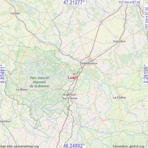
Luant GPS coordinates[2]
46° 43' 58.8" North, 1° 33' 28.548" East
| Map corner | latitude | longitude |
|---|---|---|
| Upper-left | 47.21277°, | 0.85481° |
| Center: | 46.733°, | 1.55793° |
| Lower-right: | 46.24892°, | 2.26106° |
| Map W x H: | 107.2×107.2 km | = 66.6×66.6mi |
| max Lat: | 51.07786° ⇑57.9% North |
| Luant: | 46.733° |
| min Lat: | ⇓42.1% South 41.3874° |
| min Long | Luant | max Long |
| -5.08615° | 1.55793° | 9.52242° |
| W 37.7%⇐ | ⇒62.3% E |
Elevation
Elevation of Luant is 143 m = 469 ft, and this is 50.7 m = 166 ft below average elevation for this country.
| Max E: |
2333 m = 7654 ft | 46.9% |
| Avg. | 193.7 m = 635 ft | |
| Luant | 143 m = 469 ft | |
Min E: |
-1 m = -3 ft | 53.1% |
See also: France elevation on elevation.city.
Geographical zone
Luant is located in North temperate zone (between Tropic of Cancer and the Arctic Circle). Distance of this North polar circle is 2205 km =1370.1 mi to North.| Distance of | km | miles | from Luant |
|---|---|---|---|
| North Pole | 4810.8 | 2989.3 | to North |
| Arctic Circle | 2205 | 1370.1 | to North |
| Tropic Cancer | 2590.3 | 1609.5 | to South |
| Equator | 5196.2 | 3228.8 | to South |


Nearby cities:
15 places around Luant: (largest is in red/bold)
• Argenton-sur-Creuse
16.2 km =10.1 mi,  190°
190°
• Arthon
11.6 km =7.2 mi,  112°
112°
• Chabenet
12.9 km =8 mi,  200°
200°
• Chasseneuil
10.7 km =6.6 mi,  206°
206°
• Châteauroux
13.6 km =8.5 mi,  49°
49°
• Déols
15.5 km =9.6 mi, 46°
• Le Poinçonnet
12.7 km =7.9 mi,  74°
74°
• Neuillay-les-Bois
7.2 km =4.5 mi,  300°
300°
• Niherne
10.5 km =6.5 mi,  2°
2°
• Saint-Gaultier
15.5 km =9.6 mi,  225°
225°
• Saint-Marcel
15 km =9.3 mi, 193°
• Saint-Maur
10.3 km =6.4 mi,  37°
37°
• Thenay
15.1 km =9.4 mi,  221°
221°
• Velles
8.5 km =5.3 mi,  125°
125°
• Villedieu-sur-Indre
12.6 km =7.8 mi,  353°
353°
Sources, notices
• [Note1] Compared only with cities in France existing in our database
• [Src1] Map data: © OpenStreetMap contributors (CC-BY-SA)
• [Src2] Other city data from geonames.org with taken over terms of usage.
• [Src3] Geographical zone / Annual Mean Temperature by Robert A. Rohde @ Wikipedia
