Gosné geodata
Gosné (Brittany) is a populated place; located in France in Europe/Paris (GMT+2) time zone. With population of 1,499 people, there are 6192 cities with bigger population in this country. Compared to other cities in France, 63.6% of cities are located further ↓South; 92% of cities are located further →East and 59.4% of cities have higher elevation than Gosné. Note1
Administrative division(s):
- Level 1: Brittany
- Level 2: Département d'Ille-et-Vilaine
- Level 3: Arrondissement de Rennes
- Level 4: Gosné


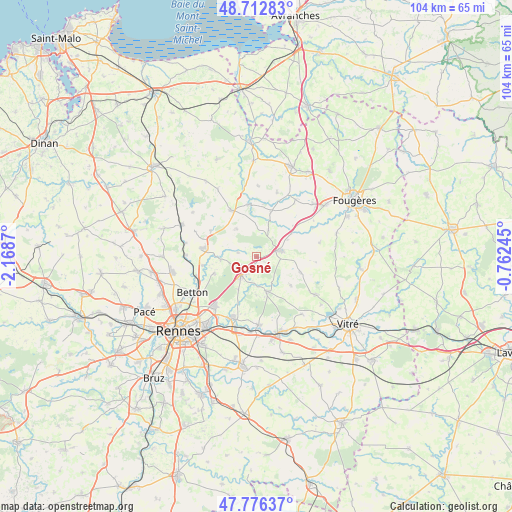
Gosné GPS coordinates[2]
48° 14' 48.264" North, 1° 27' 56.088" West
| Map corner | latitude | longitude |
|---|---|---|
| Upper-left | 48.71283°, | -2.1687° |
| Center: | 48.24674°, | -1.46558° |
| Lower-right: | 47.77637°, | -0.76245° |
| Map W x H: | 104.1×104.1 km | = 64.7×64.7mi |
| max Lat: | 51.07786° ⇑36.4% North |
| Gosné: | 48.24674° |
| min Lat: | ⇓63.6% South 41.3874° |
| min Long | Gosné | max Long |
| -5.08615° | -1.46558° | 9.52242° |
| W 8%⇐ | ⇒92% E |
Elevation
Elevation of Gosné is 104 m = 341 ft, and this is 89.7 m = 294 ft below average elevation for this country.
| Max E: |
2333 m = 7654 ft | 59.4% |
| Avg. | 193.7 m = 635 ft | |
| Gosné | 104 m = 341 ft | |
Min E: |
-1 m = -3 ft | 40.6% |
See also: France elevation on elevation.city.
Geographical zone
Gosné is located in North temperate zone (between Tropic of Cancer and the Arctic Circle). Distance of this North polar circle is 2036.6 km =1265.5 mi to North.| Distance of | km | miles | from Gosné |
|---|---|---|---|
| North Pole | 4642.5 | 2884.7 | to North |
| Arctic Circle | 2036.6 | 1265.5 | to North |
| Tropic Cancer | 2758.6 | 1714.1 | to South |
| Equator | 5364.5 | 3333.3 | to South |


Nearby cities:
15 places around Gosné: (largest is in red/bold)
• Andouillé-Neuville
10.5 km =6.5 mi,  299°
299°
• Chasné-sur-Illet
7.1 km =4.4 mi,  266°
266°
• Dourdain
9.3 km =5.8 mi,  130°
130°
• Ercé-près-Liffré
3.8 km =2.4 mi,  283°
283°
• Gahard
6.9 km =4.3 mi,  324°
324°
• La Bouëxière
7.4 km =4.6 mi,  161°
161°
• Liffré
4.9 km =3 mi,  220°
220°
• Livré-sur-Changeon
9.5 km =5.9 mi,  108°
108°
• Mouazé
10.8 km =6.7 mi,  260°
260°
• Mézières-sur-Couesnon
5.9 km =3.7 mi,  24°
24°
• Saint-Aubin-du-Cormier
4.8 km =3 mi,  74°
74°
• Saint-Jean-sur-Couesnon
8.7 km =5.4 mi,  56°
56°
• Saint-Ouen-des-Alleux
9.5 km =5.9 mi, 17°
• Saint-Sulpice-la-Forêt
9.1 km =5.7 mi,  248°
248°
• Vieux-Vy-sur-Couesnon
10.7 km =6.6 mi,  350°
350°
Sources, notices
• [Note1] Compared only with cities in France existing in our database
• [Src1] Map data: © OpenStreetMap contributors (CC-BY-SA)
• [Src2] Other city data from geonames.org with taken over terms of usage.
• [Src3] Geographical zone / Annual Mean Temperature by Robert A. Rohde @ Wikipedia
