Liffré geodata
Liffré (Brittany) is a populated place; located in France in Europe/Paris (GMT+2) time zone. With population of 7,034 people, there are 1388 cities with bigger population in this country. Compared to other cities in France, 63% of cities are located further ↓South; 92.3% of cities are located further →East and 60.4% of cities have higher elevation than Liffré. Note1
Administrative division(s):
- Level 1: Brittany
- Level 2: Département d'Ille-et-Vilaine
- Level 3: Arrondissement de Rennes
- Level 4: Liffré


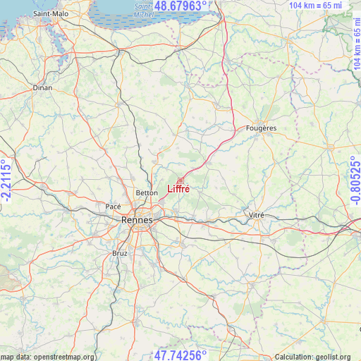
Liffré GPS coordinates[2]
48° 12' 47.664" North, 1° 30' 30.168" West
| Map corner | latitude | longitude |
|---|---|---|
| Upper-left | 48.67963°, | -2.2115° |
| Center: | 48.21324°, | -1.50838° |
| Lower-right: | 47.74256°, | -0.80525° |
| Map W x H: | 104.2×104.2 km | = 64.7×64.7mi |
| max Lat: | 51.07786° ⇑37% North |
| Liffré: | 48.21324° |
| min Lat: | ⇓63% South 41.3874° |
| min Long | Liffré | max Long |
| -5.08615° | -1.50838° | 9.52242° |
| W 7.7%⇐ | ⇒92.3% E |
Elevation
Elevation of Liffré is 101 m = 331 ft, and this is 92.7 m = 304 ft below average elevation for this country.
| Max E: |
2333 m = 7654 ft | 60.4% |
| Avg. | 193.7 m = 635 ft | |
| Liffré | 101 m = 331 ft | |
Min E: |
-1 m = -3 ft | 39.6% |
See also: France elevation on elevation.city.
Geographical zone
Liffré is located in North temperate zone (between Tropic of Cancer and the Arctic Circle). Distance of this North polar circle is 2040.4 km =1267.8 mi to North.| Distance of | km | miles | from Liffré |
|---|---|---|---|
| North Pole | 4646.3 | 2887.1 | to North |
| Arctic Circle | 2040.4 | 1267.8 | to North |
| Tropic Cancer | 2754.9 | 1711.8 | to South |
| Equator | 5360.8 | 3331 | to South |


Nearby cities:
15 places around Liffré: (largest is in red/bold)
• Acigné
9.1 km =5.7 mi,  193°
193°
• Andouillé-Neuville
10.7 km =6.6 mi,  325°
325°
• Betton
10.3 km =6.4 mi,  249°
249°
• Chasné-sur-Illet
5.1 km =3.2 mi,  309°
309°
• Chevaigné
9 km =5.6 mi,  268°
268°
• Dourdain
10.5 km =6.5 mi,  102°
102°
• Ercé-près-Liffré
4.6 km =2.9 mi,  353°
353°
• Fouillard
8.1 km =5 mi,  220°
220°
• Gahard
9.4 km =5.8 mi, 354°
• Gosné
4.9 km =3 mi,  40°
40°
• La Bouëxière
6.5 km =4 mi,  120°
120°
• Mouazé
7.8 km =4.8 mi,  285°
285°
• Mézières-sur-Couesnon
10.7 km =6.6 mi,  31°
31°
• Saint-Aubin-du-Cormier
9.3 km =5.8 mi,  57°
57°
• Saint-Sulpice-la-Forêt
5.3 km =3.3 mi, 274°
Sources, notices
• [Note1] Compared only with cities in France existing in our database
• [Src1] Map data: © OpenStreetMap contributors (CC-BY-SA)
• [Src2] Other city data from geonames.org with taken over terms of usage.
• [Src3] Geographical zone / Annual Mean Temperature by Robert A. Rohde @ Wikipedia
