L’Isle-sur-la-Sorgue geodata
L’Isle-sur-la-Sorgue (Provence-Alpes-Côte d'Azur) is a populated place; located in France in Europe/Paris (GMT+2) time zone. With population of 16,968 people, there are 560 cities with bigger population in this country. Compared to other cities in France, 87.9% of cities are located further ↑North; 78.2% of cities are located further ←West and 75.4% of cities have higher elevation than L’Isle-sur-la-Sorgue. Note1
Administrative division(s):
- Level 1: Provence-Alpes-Côte d'Azur
- Level 2: Département du Vaucluse
- Level 3: Arrondissement d’Avignon
- Level 4: L'Isle-sur-la-Sorgue


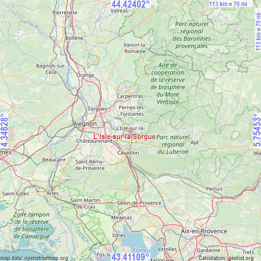
L’Isle-sur-la-Sorgue GPS coordinates[2]
43° 55' 10.956" North, 5° 3' 5.076" East
| Map corner | latitude | longitude |
|---|---|---|
| Upper-left | 44.42402°, | 4.34828° |
| Center: | 43.91971°, | 5.05141° |
| Lower-right: | 43.41109°, | 5.75453° |
| Map W x H: | 112.6×112.6 km | = 70×70mi |
| max Lat: | 51.07786° ⇑87.9% North |
| L’Isle-sur-la-Sorgue: | 43.91971° |
| min Lat: | ⇓12.1% South 41.3874° |
| min Long | L’Isle-sur-la | max Long |
| -5.08615° | 5.05141° | 9.52242° |
| W 78.2%⇐ | ⇒21.8% E |
Elevation
Elevation of L’Isle-sur-la-Sorgue is 66 m = 217 ft, and this is 127.7 m = 419 ft below average elevation for this country.
| Max E: |
2333 m = 7654 ft | 75.4% |
| Avg. | 193.7 m = 635 ft | |
| L’Isle-sur-la-Sorgue | 66 m = 217 ft | |
Min E: |
-1 m = -3 ft | 24.6% |
See also: France elevation on elevation.city.
Geographical zone
L’Isle-sur-la-Sorgue is located in North temperate zone (between Tropic of Cancer and the Arctic Circle). Distance of this Northern Tropic circle is 2277.5 km =1415.2 mi to South.| Distance of | km | miles | from L’Isle-sur-la-Sorgue |
|---|---|---|---|
| North Pole | 5123.6 | 3183.7 | to North |
| Arctic Circle | 2517.8 | 1564.5 | to North |
| Tropic Cancer | 2277.5 | 1415.2 | to South |
| Equator | 4883.4 | 3034.4 | to South |


Nearby cities:
15 places around L’Isle-sur-la-Sorgue: (largest is in red/bold)
• Cabannes
10.4 km =6.5 mi,  230°
230°
• Caumont-sur-Durance
8.8 km =5.5 mi,  250°
250°
• Cavaillon
9.9 km =6.2 mi,  187°
187°
• Châteauneuf-de-Gadagne
8.6 km =5.3 mi,  275°
275°
• Fontaine-de-Vaucluse
6.1 km =3.8 mi,  87°
87°
• Jonquerettes
10 km =6.2 mi,  287°
287°
• Lagnes
5.8 km =3.6 mi,  119°
119°
• Le Thor
4.6 km =2.9 mi, 283°
• Pernes-les-Fontaines
8.7 km =5.4 mi,  4°
4°
• Robion
9.4 km =5.8 mi,  149°
149°
• Saint-Didier
10.5 km =6.5 mi,  26°
26°
• Saint-Saturnin-lès-Avignon
10.8 km =6.7 mi, 291°
• Saumane-de-Vaucluse
4.7 km =2.9 mi,  67°
67°
• Taillades
9.6 km =6 mi,  161°
161°
• Velleron
4.5 km =2.8 mi,  337°
337°
Sources, notices
• [Note1] Compared only with cities in France existing in our database
• [Src1] Map data: © OpenStreetMap contributors (CC-BY-SA)
• [Src2] Other city data from geonames.org with taken over terms of usage.
• [Src3] Geographical zone / Annual Mean Temperature by Robert A. Rohde @ Wikipedia
