Velleron geodata
Velleron (Provence-Alpes-Côte d'Azur) is a populated place; located in France in Europe/Paris (GMT+2) time zone. With population of 3,028 people, there are 3220 cities with bigger population in this country. Compared to other cities in France, 87.5% of cities are located further ↑North; 78% of cities are located further ←West and 75.8% of cities have higher elevation than Velleron. Note1
Administrative division(s):
- Level 1: Provence-Alpes-Côte d'Azur
- Level 2: Département du Vaucluse
- Level 3: Arrondissement d’Avignon
- Level 4: Velleron


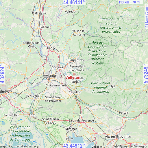
Velleron GPS coordinates[2]
43° 57' 26.712" North, 5° 1' 45.696" East
| Map corner | latitude | longitude |
|---|---|---|
| Upper-left | 44.46141°, | 4.32624° |
| Center: | 43.95742°, | 5.02936° |
| Lower-right: | 43.44912°, | 5.73249° |
| Map W x H: | 112.6×112.6 km | = 70×70mi |
| max Lat: | 51.07786° ⇑87.5% North |
| Velleron: | 43.95742° |
| min Lat: | ⇓12.5% South 41.3874° |
| min Long | Velleron | max Long |
| -5.08615° | 5.02936° | 9.52242° |
| W 78%⇐ | ⇒22% E |
Elevation
Elevation of Velleron is 65 m = 213 ft, and this is 128.7 m = 422 ft below average elevation for this country.
| Max E: |
2333 m = 7654 ft | 75.8% |
| Avg. | 193.7 m = 635 ft | |
| Velleron | 65 m = 213 ft | |
Min E: |
-1 m = -3 ft | 24.2% |
See also: France elevation on elevation.city.
Geographical zone
Velleron is located in North temperate zone (between Tropic of Cancer and the Arctic Circle). Distance of this Northern Tropic circle is 2281.7 km =1417.8 mi to South.| Distance of | km | miles | from Velleron |
|---|---|---|---|
| North Pole | 5119.5 | 3181.1 | to North |
| Arctic Circle | 2513.6 | 1561.9 | to North |
| Tropic Cancer | 2281.7 | 1417.8 | to South |
| Equator | 4887.6 | 3037 | to South |


Nearby cities:
15 places around Velleron: (largest is in red/bold)
• Althen-des-Paluds
7.7 km =4.8 mi,  312°
312°
• Caumont-sur-Durance
9.7 km =6 mi,  222°
222°
• Châteauneuf-de-Gadagne
7.6 km =4.7 mi,  243°
243°
• Entraigues-sur-la-Sorgue
9.7 km =6 mi,  301°
301°
• Fontaine-de-Vaucluse
8.7 km =5.4 mi,  116°
116°
• Jonquerettes
7.8 km =4.8 mi,  261°
261°
• Lagnes
9.9 km =6.2 mi,  136°
136°
• Le Thor
4.1 km =2.5 mi, 221°
• L’Isle-sur-la-Sorgue
4.5 km =2.8 mi,  157°
157°
• Monteux
9.1 km =5.7 mi,  343°
343°
• Pernes-les-Fontaines
5.1 km =3.2 mi,  27°
27°
• Saint-Didier
8.3 km =5.2 mi,  51°
51°
• Saint-Saturnin-lès-Avignon
8.3 km =5.2 mi,  268°
268°
• Saumane-de-Vaucluse
6.6 km =4.1 mi,  111°
111°
• Venasque
10.3 km =6.4 mi,  65°
65°
Sources, notices
• [Note1] Compared only with cities in France existing in our database
• [Src1] Map data: © OpenStreetMap contributors (CC-BY-SA)
• [Src2] Other city data from geonames.org with taken over terms of usage.
• [Src3] Geographical zone / Annual Mean Temperature by Robert A. Rohde @ Wikipedia
