Caumont-sur-Durance geodata
Caumont-sur-Durance (Provence-Alpes-Côte d'Azur) is a populated place; located in France in Europe/Paris (GMT+2) time zone. With population of 4,472 people, there are 2206 cities with bigger population in this country. Compared to other cities in France, 88.1% of cities are located further ↑North; 77.1% of cities are located further ←West and 81.8% of cities have higher elevation than Caumont-sur-Durance. Note1
Administrative division(s):
- Level 1: Provence-Alpes-Côte d'Azur
- Level 2: Département du Vaucluse
- Level 3: Arrondissement d’Avignon
- Level 4: Caumont-sur-Durance


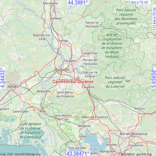
Caumont-sur-Durance GPS coordinates[2]
43° 53' 36.816" North, 4° 56' 50.82" East
| Map corner | latitude | longitude |
|---|---|---|
| Upper-left | 44.3981°, | 4.24433° |
| Center: | 43.89356°, | 4.94745° |
| Lower-right: | 43.38471°, | 5.65058° |
| Map W x H: | 112.7×112.7 km | = 70×70mi |
| max Lat: | 51.07786° ⇑88.1% North |
| Caumont-sur-Durance: | 43.89356° |
| min Lat: | ⇓11.9% South 41.3874° |
| min Long | Caumont-sur-Dur | max Long |
| -5.08615° | 4.94745° | 9.52242° |
| W 77.1%⇐ | ⇒22.9% E |
Elevation
Elevation of Caumont-sur-Durance is 50 m = 164 ft, and this is 143.7 m = 471 ft below average elevation for this country.
| Max E: |
2333 m = 7654 ft | 81.8% |
| Avg. | 193.7 m = 635 ft | |
| Caumont-sur-Durance | 50 m = 164 ft | |
Min E: |
-1 m = -3 ft | 18.2% |
See also: France elevation on elevation.city.
Geographical zone
Caumont-sur-Durance is located in North temperate zone (between Tropic of Cancer and the Arctic Circle). Distance of this Northern Tropic circle is 2274.6 km =1413.4 mi to South.| Distance of | km | miles | from Caumont-sur-Durance |
|---|---|---|---|
| North Pole | 5126.6 | 3185.5 | to North |
| Arctic Circle | 2520.7 | 1566.3 | to North |
| Tropic Cancer | 2274.6 | 1413.4 | to South |
| Equator | 4880.5 | 3032.6 | to South |


Nearby cities:
15 places around Caumont-sur-Durance: (largest is in red/bold)
• Cabannes
3.7 km =2.3 mi,  174°
174°
• Cavaillon
9.9 km =6.2 mi,  134°
134°
• Châteauneuf-de-Gadagne
3.7 km =2.3 mi,  356°
356°
• Châteaurenard
7.5 km =4.7 mi,  259°
259°
• Jonquerettes
6 km =3.7 mi,  348°
348°
• Le Thor
5.5 km =3.4 mi,  43°
43°
• L’Isle-sur-la-Sorgue
8.8 km =5.5 mi,  70°
70°
• Mollégès
9.6 km =6 mi,  179°
179°
• Montfavet
7.4 km =4.6 mi,  306°
306°
• Morières-lès-Avignon
6.4 km =4 mi,  324°
324°
• Noves
4 km =2.5 mi,  243°
243°
• Saint-Andiol
6.5 km =4 mi, 182°
• Saint-Saturnin-lès-Avignon
7.1 km =4.4 mi, 345°
• Velleron
9.7 km =6 mi, 42°
• Verquières
6.3 km =3.9 mi,  201°
201°
Sources, notices
• [Note1] Compared only with cities in France existing in our database
• [Src1] Map data: © OpenStreetMap contributors (CC-BY-SA)
• [Src2] Other city data from geonames.org with taken over terms of usage.
• [Src3] Geographical zone / Annual Mean Temperature by Robert A. Rohde @ Wikipedia
