Saint-Didier geodata
Saint-Didier (Provence-Alpes-Côte d'Azur) is a populated place; located in France in Europe/Paris (GMT+2) time zone. With population of 1,982 people, there are 4828 cities with bigger population in this country. Compared to other cities in France, 87.1% of cities are located further ↑North; 78.8% of cities are located further ←West and 60.3% of cities have lower elevation than Saint-Didier. Note1
Administrative division(s):
- Level 1: Provence-Alpes-Côte d'Azur
- Level 2: Département du Vaucluse
- Level 3: Arrondissement de Carpentras
- Level 4: Saint-Didier


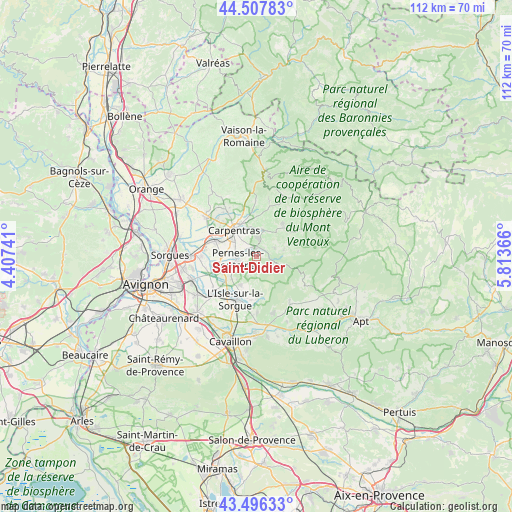
Saint-Didier GPS coordinates[2]
44° 0' 15.264" North, 5° 6' 37.908" East
| Map corner | latitude | longitude |
|---|---|---|
| Upper-left | 44.50783°, | 4.40741° |
| Center: | 44.00424°, | 5.11053° |
| Lower-right: | 43.49633°, | 5.81366° |
| Map W x H: | 112.5×112.5 km | = 69.9×69.9mi |
| max Lat: | 51.07786° ⇑87.1% North |
| Saint-Didier: | 44.00424° |
| min Lat: | ⇓12.9% South 41.3874° |
| min Long | Saint-Didier | max Long |
| -5.08615° | 5.11053° | 9.52242° |
| W 78.8%⇐ | ⇒21.2% E |
Elevation
Elevation of Saint-Didier is 171 m = 561 ft, and this is 22.7 m = 74 ft below average elevation for this country.
| Max E: |
2333 m = 7654 ft | 39.7% |
| Avg. | 193.7 m = 635 ft | |
| Saint-Didier | 171 m = 561 ft | |
Min E: |
-1 m = -3 ft | 60.3% |
See also: France elevation on elevation.city.
Geographical zone
Saint-Didier is located in North temperate zone (between Tropic of Cancer and the Arctic Circle). Distance of this Northern Tropic circle is 2286.9 km =1421 mi to South.| Distance of | km | miles | from Saint-Didier |
|---|---|---|---|
| North Pole | 5114.2 | 3177.8 | to North |
| Arctic Circle | 2508.4 | 1558.6 | to North |
| Tropic Cancer | 2286.9 | 1421 | to South |
| Equator | 4892.8 | 3040.2 | to South |


Nearby cities:
15 places around Saint-Didier: (largest is in red/bold)
• Althen-des-Paluds
12.2 km =7.6 mi,  269°
269°
• Caromb
11.9 km =7.4 mi,  358°
358°
• Carpentras
7.5 km =4.7 mi,  318°
318°
• Fontaine-de-Vaucluse
9.2 km =5.7 mi,  171°
171°
• Loriol-du-Comtat
11.9 km =7.4 mi,  312°
312°
• L’Isle-sur-la-Sorgue
10.5 km =6.5 mi,  206°
206°
• Malemort-du-Comtat
4.3 km =2.7 mi,  64°
64°
• Mazan
6 km =3.7 mi,  12°
12°
• Monteux
9.8 km =6.1 mi,  291°
291°
• Mormoiron
9.2 km =5.7 mi,  39°
39°
• Pernes-les-Fontaines
4.2 km =2.6 mi,  260°
260°
• Saumane-de-Vaucluse
7.6 km =4.7 mi,  182°
182°
• Velleron
8.3 km =5.2 mi,  231°
231°
• Venasque
3 km =1.9 mi,  107°
107°
• Villes-sur-Auzon
11.5 km =7.1 mi, 59°
Sources, notices
• [Note1] Compared only with cities in France existing in our database
• [Src1] Map data: © OpenStreetMap contributors (CC-BY-SA)
• [Src2] Other city data from geonames.org with taken over terms of usage.
• [Src3] Geographical zone / Annual Mean Temperature by Robert A. Rohde @ Wikipedia
