Limogne-en-Quercy geodata
Limogne-en-Quercy (Occitanie) is a populated place; located in France in Europe/Paris (GMT+2) time zone. With population of 778 people, there are 10845 cities with bigger population in this country. Compared to other cities in France, 84.2% of cities are located further ↑North; 59.5% of cities are located further →East and 81.7% of cities have lower elevation than Limogne-en-Quercy. Note1
Administrative division(s):
- Level 1: Occitanie
- Level 2: Lot
- Level 3: Arrondissement de Cahors
- Level 4: Limogne-en-Quercy


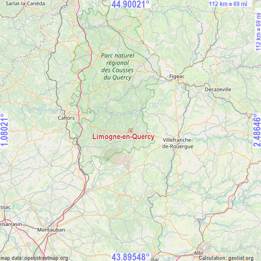
Limogne-en-Quercy GPS coordinates[2]
44° 24' 0" North, 1° 46' 59.988" East
| Map corner | latitude | longitude |
|---|---|---|
| Upper-left | 44.90021°, | 1.08021° |
| Center: | 44.4°, | 1.78333° |
| Lower-right: | 43.89548°, | 2.48646° |
| Map W x H: | 111.7×111.7 km | = 69.4×69.4mi |
| max Lat: | 51.07786° ⇑84.2% North |
| Limogne-en-Quercy: | 44.4° |
| min Lat: | ⇓15.8% South 41.3874° |
| min Long | Limogne-en-Quer | max Long |
| -5.08615° | 1.78333° | 9.52242° |
| W 40.5%⇐ | ⇒59.5% E |
Elevation
Elevation of Limogne-en-Quercy is 307 m = 1007 ft, and this is 113.3 m = 372 ft above average elevation for this country.
| Max E: |
2333 m = 7654 ft | 18.3% |
| Limogne-en-Quercy | 307 m 1007 ft | |
| Avg. | 193.7 m = 635 ft | |
Min E: |
-1 m = -3 ft | 81.7% |
See also: France elevation on elevation.city.
Geographical zone
Limogne-en-Quercy is located in North temperate zone (between Tropic of Cancer and the Arctic Circle). Distance of this Northern Tropic circle is 2330.9 km =1448.4 mi to South.| Distance of | km | miles | from Limogne-en-Quercy |
|---|---|---|---|
| North Pole | 5070.2 | 3150.5 | to North |
| Arctic Circle | 2464.4 | 1531.3 | to North |
| Tropic Cancer | 2330.9 | 1448.4 | to South |
| Equator | 4936.8 | 3067.6 | to South |


Nearby cities:
15 places around Limogne-en-Quercy: (largest is in red/bold)
• Arcambal
22.4 km =13.9 mi,  286°
286°
• Cajarc
10.6 km =6.6 mi,  26°
26°
• Caylus
18.3 km =11.4 mi,  182°
182°
• Flaujac-Poujols
22.5 km =14 mi,  271°
271°
• La Rouquette
18.7 km =11.6 mi,  125°
125°
• Lalbenque
20.1 km =12.5 mi,  250°
250°
• Martiel
11.4 km =7.1 mi,  103°
103°
• Monteils
22.7 km =14.1 mi, 131°
• Morlhon-le-Haut
23.8 km =14.8 mi,  110°
110°
• Puylaroque
21.5 km =13.4 mi,  219°
219°
• Savignac
15.2 km =9.4 mi, 107°
• Toulonjac
17.4 km =10.8 mi, 96°
• Vailhourles
14.4 km =8.9 mi,  136°
136°
• Villefranche-de-Rouergue
20.9 km =13 mi, 104°
• Villeneuve
20.2 km =12.6 mi,  79°
79°
Sources, notices
• [Note1] Compared only with cities in France existing in our database
• [Src1] Map data: © OpenStreetMap contributors (CC-BY-SA)
• [Src2] Other city data from geonames.org with taken over terms of usage.
• [Src3] Geographical zone / Annual Mean Temperature by Robert A. Rohde @ Wikipedia
