Ligny-en-Barrois geodata
Ligny-en-Barrois (Grand Est) is a populated place; located in France in Europe/Paris (GMT+2) time zone. With population of 5,247 people, there are 1873 cities with bigger population in this country. Compared to other cities in France, 72.9% of cities are located further ↓South; 80.8% of cities are located further ←West and 71.2% of cities have lower elevation than Ligny-en-Barrois. Note1
Administrative division(s):
- Level 1: Grand Est
- Level 2: Meuse
- Level 3: Arrondissement de Bar-le-Duc
- Level 4: Ligny-en-Barrois


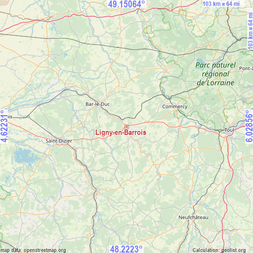
Ligny-en-Barrois GPS coordinates[2]
48° 41' 18.996" North, 5° 19' 31.548" East
| Map corner | latitude | longitude |
|---|---|---|
| Upper-left | 49.15064°, | 4.62231° |
| Center: | 48.68861°, | 5.32543° |
| Lower-right: | 48.2223°, | 6.02856° |
| Map W x H: | 103.2×103.2 km | = 64.1×64.1mi |
| max Lat: | 51.07786° ⇑27.1% North |
| Ligny-en-Barrois: | 48.68861° |
| min Lat: | ⇓72.9% South 41.3874° |
| min Long | Ligny-en-Barroi | max Long |
| -5.08615° | 5.32543° | 9.52242° |
| W 80.8%⇐ | ⇒19.2% E |
Elevation
Elevation of Ligny-en-Barrois is 225 m = 738 ft, and this is 31.3 m = 103 ft above average elevation for this country.
| Max E: |
2333 m = 7654 ft | 28.8% |
| Ligny-en-Barrois | 225 m 738 ft | |
| Avg. | 193.7 m = 635 ft | |
Min E: |
-1 m = -3 ft | 71.2% |
See also: France elevation on elevation.city.
Geographical zone
Ligny-en-Barrois is located in North temperate zone (between Tropic of Cancer and the Arctic Circle). Distance of this North polar circle is 1987.5 km =1235 mi to North.| Distance of | km | miles | from Ligny-en-Barrois |
|---|---|---|---|
| North Pole | 4593.4 | 2854.2 | to North |
| Arctic Circle | 1987.5 | 1235 | to North |
| Tropic Cancer | 2807.7 | 1744.6 | to South |
| Equator | 5413.7 | 3363.9 | to South |


Nearby cities:
15 places around Ligny-en-Barrois: (largest is in red/bold)
• Bar-le-Duc
15.3 km =9.5 mi,  307°
307°
• Behonne
15.7 km =9.8 mi,  318°
318°
• Brillon-en-Barrois
17.1 km =10.6 mi,  278°
278°
• Combles-en-Barrois
16.9 km =10.5 mi,  294°
294°
• Demange-aux-Eaux
15.5 km =9.6 mi,  140°
140°
• Fains-Véel
17.6 km =10.9 mi, 306°
• Haironville
17.6 km =10.9 mi,  269°
269°
• Longeville-en-Barrois
10.4 km =6.5 mi, 305°
• Lérouville
19.6 km =12.2 mi,  53°
53°
• Naives-Rosières
13.2 km =8.2 mi, 322°
• Savonnières-devant-Bar
13.3 km =8.3 mi, 305°
• Tronville-en-Barrois
4.9 km =3 mi, 314°
• Tréveray
10.2 km =6.3 mi,  148°
148°
• Vacon
20.3 km =12.6 mi,  96°
96°
• Velaines
1.9 km =1.2 mi, 306°
Sources, notices
• [Note1] Compared only with cities in France existing in our database
• [Src1] Map data: © OpenStreetMap contributors (CC-BY-SA)
• [Src2] Other city data from geonames.org with taken over terms of usage.
• [Src3] Geographical zone / Annual Mean Temperature by Robert A. Rohde @ Wikipedia
