Bar-le-Duc geodata
Bar-le-Duc (Grand Est) is a seat of a second-order administrative division; located in France in Europe/Paris (GMT+2) time zone. With population of 18,595 people, there are 504 cities with bigger population in this country. Compared to other cities in France, 74.9% of cities are located further ↓South; 79.3% of cities are located further ←West and 63.1% of cities have lower elevation than Bar-le-Duc. Note1
Administrative division(s):
- Level 1: Grand Est
- Level 2: Meuse
- Level 3: Arrondissement de Bar-le-Duc
- Level 4: Bar-le-Duc


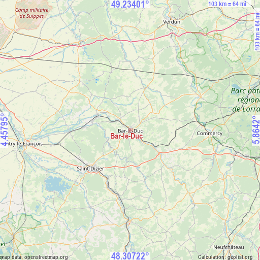
Bar-le-Duc GPS coordinates[2]
48° 46' 21.9" North, 5° 9' 39.888" East
| Map corner | latitude | longitude |
|---|---|---|
| Upper-left | 49.23401°, | 4.45795° |
| Center: | 48.77275°, | 5.16108° |
| Lower-right: | 48.30722°, | 5.8642° |
| Map W x H: | 103×103 km | = 64×64mi |
| max Lat: | 51.07786° ⇑25.1% North |
| Bar-le-Duc: | 48.77275° |
| min Lat: | ⇓74.9% South 41.3874° |
| min Long | Bar-le-Duc | max Long |
| -5.08615° | 5.16108° | 9.52242° |
| W 79.3%⇐ | ⇒20.7% E |
Elevation
Elevation of Bar-le-Duc is 185 m = 607 ft, and this is 8.7 m = 29 ft below average elevation for this country.
| Max E: |
2333 m = 7654 ft | 36.9% |
| Avg. | 193.7 m = 635 ft | |
| Bar-le-Duc | 185 m = 607 ft | |
Min E: |
-1 m = -3 ft | 63.1% |
See also: France elevation on elevation.city.
Geographical zone
Bar-le-Duc is located in North temperate zone (between Tropic of Cancer and the Arctic Circle). Distance of this North polar circle is 1978.2 km =1229.2 mi to North.| Distance of | km | miles | from Bar-le-Duc |
|---|---|---|---|
| North Pole | 4584 | 2848.4 | to North |
| Arctic Circle | 1978.2 | 1229.2 | to North |
| Tropic Cancer | 2817.1 | 1750.5 | to South |
| Equator | 5423 | 3369.7 | to South |


Nearby cities:
15 places around Bar-le-Duc: (largest is in red/bold)
• Behonne
2.8 km =1.7 mi,  34°
34°
• Beurey-sur-Saulx
10 km =6.2 mi,  260°
260°
• Brillon-en-Barrois
8.3 km =5.2 mi,  215°
215°
• Combles-en-Barrois
4.1 km =2.5 mi,  234°
234°
• Fains-Véel
2.3 km =1.4 mi,  300°
300°
• Haironville
11 km =6.8 mi,  210°
210°
• Lisle-en-Rigault
10.4 km =6.5 mi, 233°
• Longeville-en-Barrois
4.9 km =3 mi,  133°
133°
• Naives-Rosières
4.2 km =2.6 mi,  73°
73°
• Revigny-sur-Ornain
14.4 km =8.9 mi, 296°
• Robert-Espagne
10.1 km =6.3 mi,  251°
251°
• Savonnières-devant-Bar
2.1 km =1.3 mi,  143°
143°
• Tronville-en-Barrois
10.4 km =6.5 mi,  124°
124°
• Trémont-sur-Saulx
7.9 km =4.9 mi, 250°
• Velaines
13.4 km =8.3 mi, 127°
Sources, notices
• [Note1] Compared only with cities in France existing in our database
• [Src1] Map data: © OpenStreetMap contributors (CC-BY-SA)
• [Src2] Other city data from geonames.org with taken over terms of usage.
• [Src3] Geographical zone / Annual Mean Temperature by Robert A. Rohde @ Wikipedia
