Lignan-sur-Orb geodata
Lignan-sur-Orb (Occitanie) is a populated place; located in France in Europe/Paris (GMT+2) time zone. With population of 3,232 people, there are 3021 cities with bigger population in this country. Compared to other cities in France, 94.4% of cities are located further ↑North; 60.2% of cities are located further ←West and 91.6% of cities have higher elevation than Lignan-sur-Orb. Note1
Administrative division(s):
- Level 1: Occitanie
- Level 2: Département de l'Hérault
- Level 3: Arrondissement de Béziers
- Level 4: Lignan-sur-Orb


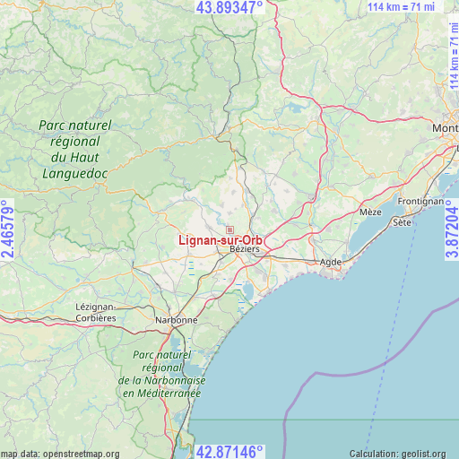
Lignan-sur-Orb GPS coordinates[2]
43° 23' 4.632" North, 3° 10' 8.076" East
| Map corner | latitude | longitude |
|---|---|---|
| Upper-left | 43.89347°, | 2.46579° |
| Center: | 43.38462°, | 3.16891° |
| Lower-right: | 42.87146°, | 3.87204° |
| Map W x H: | 113.6×113.6 km | = 70.6×70.6mi |
| max Lat: | 51.07786° ⇑94.4% North |
| Lignan-sur-Orb: | 43.38462° |
| min Lat: | ⇓5.6% South 41.3874° |
| min Long | Lignan-sur-Orb | max Long |
| -5.08615° | 3.16891° | 9.52242° |
| W 60.2%⇐ | ⇒39.8% E |
Elevation
Elevation of Lignan-sur-Orb is 26 m = 85 ft, and this is 167.7 m = 550 ft below average elevation for this country.
| Max E: |
2333 m = 7654 ft | 91.6% |
| Avg. | 193.7 m = 635 ft | |
| Lignan-sur-Orb | 26 m = 85 ft | |
Min E: |
-1 m = -3 ft | 8.4% |
See also: France elevation on elevation.city.
Geographical zone
Lignan-sur-Orb is located in North temperate zone (between Tropic of Cancer and the Arctic Circle). Distance of this Northern Tropic circle is 2218 km =1378.2 mi to South.| Distance of | km | miles | from Lignan-sur-Orb |
|---|---|---|---|
| North Pole | 5183.1 | 3220.6 | to North |
| Arctic Circle | 2577.3 | 1601.5 | to North |
| Tropic Cancer | 2218 | 1378.2 | to South |
| Equator | 4823.9 | 2997.4 | to South |


Nearby cities:
15 places around Lignan-sur-Orb: (largest is in red/bold)
• Bassan
7.5 km =4.7 mi,  67°
67°
• Boujan-sur-Libron
6.6 km =4.1 mi,  104°
104°
• Béziers
6 km =3.7 mi,  142°
142°
• Cazouls-lès-Béziers
5.6 km =3.5 mi,  278°
278°
• Colombiers
8.2 km =5.1 mi,  196°
196°
• Corneilhan
2.5 km =1.6 mi,  47°
47°
• Lieuran-lès-Béziers
6.7 km =4.2 mi,  55°
55°
• Maraussan
2 km =1.2 mi,  210°
210°
• Maureilhan
5.7 km =3.5 mi,  227°
227°
• Montady
6.4 km =4 mi, 211°
• Murviel-lès-Béziers
6.1 km =3.8 mi,  332°
332°
• Pailhès
5.3 km =3.3 mi,  14°
14°
• Puimisson
6.6 km =4.1 mi,  26°
26°
• Saint-Geniès-de-Fontedit
9.2 km =5.7 mi, 7°
• Thézan-lès-Béziers
3.6 km =2.2 mi,  357°
357°
Sources, notices
• [Note1] Compared only with cities in France existing in our database
• [Src1] Map data: © OpenStreetMap contributors (CC-BY-SA)
• [Src2] Other city data from geonames.org with taken over terms of usage.
• [Src3] Geographical zone / Annual Mean Temperature by Robert A. Rohde @ Wikipedia
