Lieu-Saint-Amand geodata
Lieu-Saint-Amand (Hauts-de-France) is a populated place; located in France in Europe/Paris (GMT+2) time zone. With population of 1,272 people, there are 7168 cities with bigger population in this country. Compared to other cities in France, 95.3% of cities are located further ↓South; 62.6% of cities are located further ←West and 77% of cities have higher elevation than Lieu-Saint-Amand. Note1
Administrative division(s):
- Level 1: Hauts-de-France
- Level 2: Nord
- Level 3: Arrondissement de Valenciennes
- Level 4: Lieu-Saint-Amand


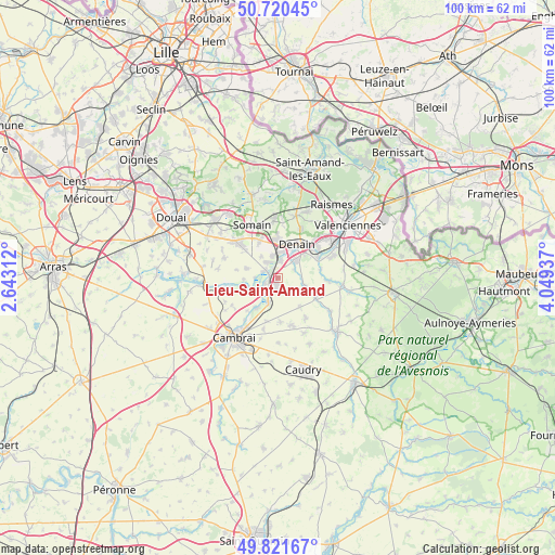
Lieu-Saint-Amand GPS coordinates[2]
50° 16' 23.448" North, 3° 20' 46.464" East
| Map corner | latitude | longitude |
|---|---|---|
| Upper-left | 50.72045°, | 2.64312° |
| Center: | 50.27318°, | 3.34624° |
| Lower-right: | 49.82167°, | 4.04937° |
| Map W x H: | 99.9×99.9 km | = 62.1×62.1mi |
| max Lat: | 51.07786° ⇑4.7% North |
| Lieu-Saint-Amand: | 50.27318° |
| min Lat: | ⇓95.3% South 41.3874° |
| min Long | Lieu-Saint-Aman | max Long |
| -5.08615° | 3.34624° | 9.52242° |
| W 62.6%⇐ | ⇒37.4% E |
Elevation
Elevation of Lieu-Saint-Amand is 62 m = 203 ft, and this is 131.7 m = 432 ft below average elevation for this country.
| Max E: |
2333 m = 7654 ft | 77% |
| Avg. | 193.7 m = 635 ft | |
| Lieu-Saint-Amand | 62 m = 203 ft | |
Min E: |
-1 m = -3 ft | 23% |
See also: France elevation on elevation.city.
Geographical zone
Lieu-Saint-Amand is located in North temperate zone (between Tropic of Cancer and the Arctic Circle). Distance of this North polar circle is 1811.3 km =1125.5 mi to North.| Distance of | km | miles | from Lieu-Saint-Amand |
|---|---|---|---|
| North Pole | 4417.2 | 2744.7 | to North |
| Arctic Circle | 1811.3 | 1125.5 | to North |
| Tropic Cancer | 2983.9 | 1854.1 | to South |
| Equator | 5589.9 | 3473.4 | to South |


Nearby cities:
15 places around Lieu-Saint-Amand: (largest is in red/bold)
• Avesnes-le-Sec
3.3 km =2.1 mi,  137°
137°
• Bouchain
2.6 km =1.6 mi,  300°
300°
• Douchy-les-Mines
4.5 km =2.8 mi,  47°
47°
• Haspres
5.3 km =3.3 mi,  108°
108°
• Hordain
2.6 km =1.6 mi,  244°
244°
• Iwuy
4.8 km =3 mi,  202°
202°
• Lourches
4.5 km =2.8 mi,  5°
5°
• Marquette-en-Ostrevant
5.8 km =3.6 mi,  281°
281°
• Mastaing
4.7 km =2.9 mi,  321°
321°
• Neuville-sur-Escaut
3 km =1.9 mi, 5°
• Noyelles-sur-Selle
3.2 km =2 mi,  64°
64°
• Paillencourt
5.9 km =3.7 mi, 240°
• Rœulx
3.1 km =1.9 mi,  342°
342°
• Villers-en-Cauchies
6.7 km =4.2 mi, 142°
• Wasnes-au-Bac
6.1 km =3.8 mi,  267°
267°
Sources, notices
• [Note1] Compared only with cities in France existing in our database
• [Src1] Map data: © OpenStreetMap contributors (CC-BY-SA)
• [Src2] Other city data from geonames.org with taken over terms of usage.
• [Src3] Geographical zone / Annual Mean Temperature by Robert A. Rohde @ Wikipedia
