Iwuy geodata
Iwuy (Hauts-de-France) is a populated place; located in France in Europe/Paris (GMT+2) time zone. With population of 3,140 people, there are 3098 cities with bigger population in this country. Compared to other cities in France, 95% of cities are located further ↓South; 62.3% of cities are located further ←West and 82.6% of cities have higher elevation than Iwuy. Note1
Administrative division(s):
- Level 1: Hauts-de-France
- Level 2: Nord
- Level 3: Arrondissement de Cambrai
- Level 4: Iwuy


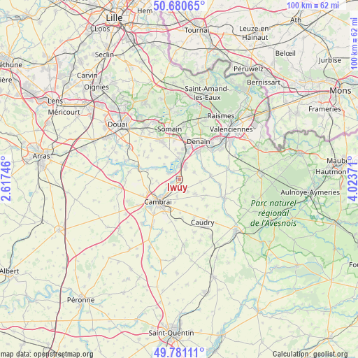
Iwuy GPS coordinates[2]
50° 13' 58.8" North, 3° 19' 14.088" East
| Map corner | latitude | longitude |
|---|---|---|
| Upper-left | 50.68065°, | 2.61746° |
| Center: | 50.233°, | 3.32058° |
| Lower-right: | 49.78111°, | 4.02371° |
| Map W x H: | 100×100 km | = 62.1×62.1mi |
| max Lat: | 51.07786° ⇑5% North |
| Iwuy: | 50.233° |
| min Lat: | ⇓95% South 41.3874° |
| min Long | Iwuy | max Long |
| -5.08615° | 3.32058° | 9.52242° |
| W 62.3%⇐ | ⇒37.7% E |
Elevation
Elevation of Iwuy is 48 m = 157 ft, and this is 145.7 m = 478 ft below average elevation for this country.
| Max E: |
2333 m = 7654 ft | 82.6% |
| Avg. | 193.7 m = 635 ft | |
| Iwuy | 48 m = 157 ft | |
Min E: |
-1 m = -3 ft | 17.4% |
See also: France elevation on elevation.city.
Geographical zone
Iwuy is located in North temperate zone (between Tropic of Cancer and the Arctic Circle). Distance of this North polar circle is 1815.8 km =1128.3 mi to North.| Distance of | km | miles | from Iwuy |
|---|---|---|---|
| North Pole | 4421.7 | 2747.5 | to North |
| Arctic Circle | 1815.8 | 1128.3 | to North |
| Tropic Cancer | 2979.5 | 1851.4 | to South |
| Equator | 5585.4 | 3470.6 | to South |


Nearby cities:
15 places around Iwuy: (largest is in red/bold)
• Avesnes-le-Sec
4.5 km =2.8 mi,  63°
63°
• Avesnes-les-Aubert
5.8 km =3.6 mi,  129°
129°
• Bouchain
5.8 km =3.6 mi,  356°
356°
• Cauroir
6.8 km =4.2 mi,  190°
190°
• Escaudœuvres
5.3 km =3.3 mi,  226°
226°
• Hem-Lenglet
7.1 km =4.4 mi,  292°
292°
• Hordain
3.4 km =2.1 mi,  351°
351°
• Lieu-Saint-Amand
4.8 km =3 mi,  22°
22°
• Marquette-en-Ostrevant
6.8 km =4.2 mi,  325°
325°
• Naves
3.4 km =2.1 mi,  184°
184°
• Paillencourt
3.6 km =2.2 mi,  295°
295°
• Ramillies
5.2 km =3.2 mi, 233°
• Rieux-en-Cambrésis
4.2 km =2.6 mi,  147°
147°
• Villers-en-Cauchies
6 km =3.7 mi,  97°
97°
• Wasnes-au-Bac
6 km =3.7 mi,  314°
314°
Sources, notices
• [Note1] Compared only with cities in France existing in our database
• [Src1] Map data: © OpenStreetMap contributors (CC-BY-SA)
• [Src2] Other city data from geonames.org with taken over terms of usage.
• [Src3] Geographical zone / Annual Mean Temperature by Robert A. Rohde @ Wikipedia
