Pinsac geodata
Pinsac (Occitanie) is a populated place; located in France in Europe/Paris (GMT+2) time zone. With population of 762 people, there are 11040 cities with bigger population in this country. Compared to other cities in France, 80.8% of cities are located further ↑North; 62.9% of cities are located further →East and 50.2% of cities have higher elevation than Pinsac. Note1
Administrative division(s):
- Level 1: Occitanie
- Level 2: Lot
- Level 3: Arrondissement de Gourdon
- Level 4: Pinsac


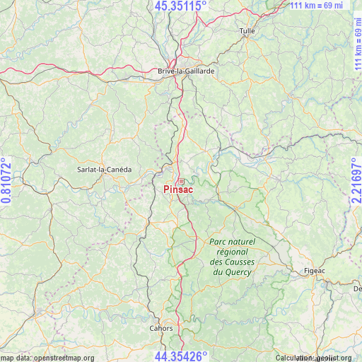
Pinsac GPS coordinates[2]
44° 51' 17.496" North, 1° 30' 49.86" East
| Map corner | latitude | longitude |
|---|---|---|
| Upper-left | 45.35115°, | 0.81072° |
| Center: | 44.85486°, | 1.51385° |
| Lower-right: | 44.35426°, | 2.21697° |
| Map W x H: | 110.8×110.8 km | = 68.8×68.8mi |
| max Lat: | 51.07786° ⇑80.8% North |
| Pinsac: | 44.85486° |
| min Lat: | ⇓19.2% South 41.3874° |
| min Long | Pinsac | max Long |
| -5.08615° | 1.51385° | 9.52242° |
| W 37.1%⇐ | ⇒62.9% E |
Elevation
Elevation of Pinsac is 131 m = 430 ft, and this is 62.7 m = 206 ft below average elevation for this country.
| Max E: |
2333 m = 7654 ft | 50.2% |
| Avg. | 193.7 m = 635 ft | |
| Pinsac | 131 m = 430 ft | |
Min E: |
-1 m = -3 ft | 49.8% |
See also: France elevation on elevation.city.
Geographical zone
Pinsac is located in North temperate zone (between Tropic of Cancer and the Arctic Circle). Distance of this Northern Tropic circle is 2381.5 km =1479.8 mi to South.| Distance of | km | miles | from Pinsac |
|---|---|---|---|
| North Pole | 5019.7 | 3119.1 | to North |
| Arctic Circle | 2413.8 | 1499.9 | to North |
| Tropic Cancer | 2381.5 | 1479.8 | to South |
| Equator | 4987.4 | 3099 | to South |


Nearby cities:
15 places around Pinsac: (largest is in red/bold)
• Alvignac
14.6 km =9.1 mi,  102°
102°
• Carlux
13.3 km =8.3 mi,  283°
283°
• Eyvigues-et-Eybènes
15.6 km =9.7 mi,  304°
304°
• Gignac
17.3 km =10.7 mi,  345°
345°
• Gourdon
16.6 km =10.3 mi,  218°
218°
• Groléjac
18 km =11.2 mi,  257°
257°
• Lachapelle-Auzac
8.4 km =5.2 mi, 348°
• Lanzac
3.2 km =2 mi,  311°
311°
• Le Vigan
14 km =8.7 mi,  204°
204°
• Martel
11.8 km =7.3 mi,  39°
39°
• Payrac
7.3 km =4.5 mi,  206°
206°
• Payrignac
16.9 km =10.5 mi,  229°
229°
• Rocamadour
10.3 km =6.4 mi,  126°
126°
• Saint-Julien-de-Lampon
13 km =8.1 mi, 275°
• Souillac
5.7 km =3.5 mi,  325°
325°
Sources, notices
• [Note1] Compared only with cities in France existing in our database
• [Src1] Map data: © OpenStreetMap contributors (CC-BY-SA)
• [Src2] Other city data from geonames.org with taken over terms of usage.
• [Src3] Geographical zone / Annual Mean Temperature by Robert A. Rohde @ Wikipedia
