Épieds geodata
Épieds (Pays de la Loire) is a populated place; located in France in Europe/Paris (GMT+2) time zone. With population of 574 people, there are 13763 cities with bigger population in this country. Compared to other cities in France, 53.7% of cities are located further ↑North; 78.5% of cities are located further →East and 87.8% of cities have higher elevation than Épieds. Note1
Administrative division(s):
- Level 1: Pays de la Loire
- Level 2: Département de Maine-et-Loire
- Level 3: Arrondissement de Saumur
- Level 4: Épieds


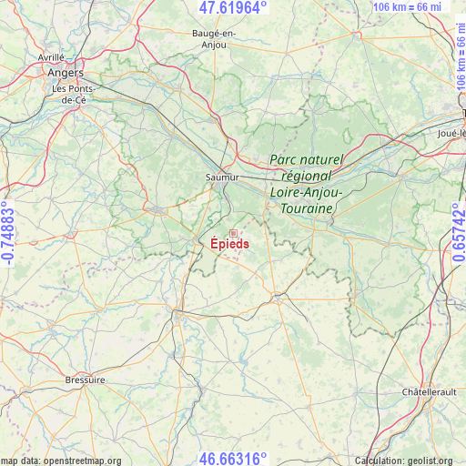
Épieds GPS coordinates[2]
47° 8' 36.78" North, 0° 2' 44.52" West
| Map corner | latitude | longitude |
|---|---|---|
| Upper-left | 47.61964°, | -0.74883° |
| Center: | 47.14355°, | -0.0457° |
| Lower-right: | 46.66316°, | 0.65742° |
| Map W x H: | 106.4×106.3 km | = 66.1×66.1mi |
| max Lat: | 51.07786° ⇑53.7% North |
| Épieds: | 47.14355° |
| min Lat: | ⇓46.3% South 41.3874° |
| min Long | Épieds | max Long |
| -5.08615° | -0.0457° | 9.52242° |
| W 21.5%⇐ | ⇒78.5% E |
Elevation
Elevation of Épieds is 35 m = 115 ft, and this is 158.7 m = 521 ft below average elevation for this country.
| Max E: |
2333 m = 7654 ft | 87.8% |
| Avg. | 193.7 m = 635 ft | |
| Épieds | 35 m = 115 ft | |
Min E: |
-1 m = -3 ft | 12.2% |
See also: France elevation on elevation.city.
Geographical zone
Épieds is located in North temperate zone (between Tropic of Cancer and the Arctic Circle). Distance of this North polar circle is 2159.3 km =1341.7 mi to North.| Distance of | km | miles | from Épieds |
|---|---|---|---|
| North Pole | 4765.2 | 2961 | to North |
| Arctic Circle | 2159.3 | 1341.7 | to North |
| Tropic Cancer | 2636 | 1637.9 | to South |
| Equator | 5241.9 | 3257.2 | to South |


Nearby cities:
15 places around Épieds: (largest is in red/bold)
• Brézé
3.5 km =2.2 mi,  341°
341°
• Chacé
8.1 km =5 mi,  345°
345°
• Distré
10.1 km =6.3 mi,  330°
330°
• Fontevraud-l'Abbaye
8.5 km =5.3 mi,  58°
58°
• Le Coudray-Macouard
8 km =5 mi,  317°
317°
• Les Trois-Moutiers
10.2 km =6.3 mi,  150°
150°
• Montreuil-Bellay
8.2 km =5.1 mi,  260°
260°
• Montsoreau
11.4 km =7.1 mi,  45°
45°
• Roiffé
7.7 km =4.8 mi,  106°
106°
• Saint-Cyr-en-Bourg
5.9 km =3.7 mi, 348°
• Souzay-Champigny
10.7 km =6.6 mi,  14°
14°
• Varennes-sur-Loire
12.9 km =8 mi,  35°
35°
• Varrains
8.9 km =5.5 mi, 352°
• Vaudelnay
12.2 km =7.6 mi,  267°
267°
• Villebernier
12.3 km =7.6 mi,  4°
4°
Sources, notices
• [Note1] Compared only with cities in France existing in our database
• [Src1] Map data: © OpenStreetMap contributors (CC-BY-SA)
• [Src2] Other city data from geonames.org with taken over terms of usage.
• [Src3] Geographical zone / Annual Mean Temperature by Robert A. Rohde @ Wikipedia
