Fontevraud-l'Abbaye geodata
Fontevraud-l'Abbaye (Pays de la Loire) is a populated place; located in France in Europe/Paris (GMT+2) time zone. With population of 1,497 people, there are 6199 cities with bigger population in this country. Compared to other cities in France, 53.2% of cities are located further ↑North; 77.7% of cities are located further →East and 72.6% of cities have higher elevation than Fontevraud-l'Abbaye. Note1
Administrative division(s):
- Level 1: Pays de la Loire
- Level 2: Département de Maine-et-Loire
- Level 3: Arrondissement de Saumur
- Level 4: Fontevraud-l'Abbaye


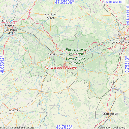
Fontevraud-l'Abbaye GPS coordinates[2]
47° 10' 59.988" North, 0° 3' 0" East
| Map corner | latitude | longitude |
|---|---|---|
| Upper-left | 47.65906°, | -0.65312° |
| Center: | 47.18333°, | 0.05° |
| Lower-right: | 46.7033°, | 0.75313° |
| Map W x H: | 106.3×106.3 km | = 66.1×66.1mi |
| max Lat: | 51.07786° ⇑53.2% North |
| Fontevraud-l'Abbaye: | 47.18333° |
| min Lat: | ⇓46.8% South 41.3874° |
| min Long | Fontevraud-l'Ab | max Long |
| -5.08615° | 0.05° | 9.52242° |
| W 22.3%⇐ | ⇒77.7% E |
Elevation
Elevation of Fontevraud-l'Abbaye is 72 m = 236 ft, and this is 121.7 m = 399 ft below average elevation for this country.
| Max E: |
2333 m = 7654 ft | 72.6% |
| Avg. | 193.7 m = 635 ft | |
| Fontevraud-l'Abbaye | 72 m = 236 ft | |
Min E: |
-1 m = -3 ft | 27.4% |
See also: France elevation on elevation.city.
Geographical zone
Fontevraud-l'Abbaye is located in North temperate zone (between Tropic of Cancer and the Arctic Circle). Distance of this North polar circle is 2154.9 km =1339 mi to North.| Distance of | km | miles | from Fontevraud-l'Abbaye |
|---|---|---|---|
| North Pole | 4760.8 | 2958.2 | to North |
| Arctic Circle | 2154.9 | 1339 | to North |
| Tropic Cancer | 2640.4 | 1640.7 | to South |
| Equator | 5246.3 | 3259.9 | to South |


Nearby cities:
15 places around Fontevraud-l'Abbaye: (largest is in red/bold)
• Allonnes
12.4 km =7.7 mi,  351°
351°
• Avoine
10.3 km =6.4 mi,  76°
76°
• Beaumont-en-Véron
10.2 km =6.3 mi, 83°
• Brézé
8.4 km =5.2 mi,  262°
262°
• Chacé
9.8 km =6.1 mi,  290°
290°
• Chouzé-sur-Loire
8.1 km =5 mi,  43°
43°
• Montsoreau
3.7 km =2.3 mi,  13°
13°
• Roiffé
6.6 km =4.1 mi,  178°
178°
• Saint-Cyr-en-Bourg
8.5 km =5.3 mi,  278°
278°
• Savigny-en-Véron
7.4 km =4.6 mi,  74°
74°
• Souzay-Champigny
7.4 km =4.6 mi,  322°
322°
• Varennes-sur-Loire
6 km =3.7 mi,  2°
2°
• Varrains
9.4 km =5.8 mi,  297°
297°
• Villebernier
10 km =6.2 mi, 321°
• Épieds
8.5 km =5.3 mi,  238°
238°
Sources, notices
• [Note1] Compared only with cities in France existing in our database
• [Src1] Map data: © OpenStreetMap contributors (CC-BY-SA)
• [Src2] Other city data from geonames.org with taken over terms of usage.
• [Src3] Geographical zone / Annual Mean Temperature by Robert A. Rohde @ Wikipedia
