Chamonix-Mont-Blanc geodata
Chamonix-Mont-Blanc (Auvergne-Rhône-Alpes) is a populated place; located in France in Europe/Paris (GMT+2) time zone. With population of 10,614 people, there are 898 cities with bigger population in this country. Compared to other cities in France, 67.2% of cities are located further ↑North; 94.1% of cities are located further ←West and 99.3% of cities have lower elevation than Chamonix-Mont-Blanc. Note1
Administrative division(s):
- Level 1: Auvergne-Rhône-Alpes
- Level 2: Haute-Savoie
- Level 3: Arrondissement de Bonneville
- Level 4: Chamonix-Mont-Blanc


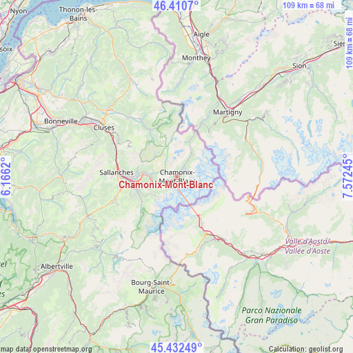
Chamonix-Mont-Blanc GPS coordinates[2]
45° 55' 25.5" North, 6° 52' 9.588" East
| Map corner | latitude | longitude |
|---|---|---|
| Upper-left | 46.4107°, | 6.1662° |
| Center: | 45.92375°, | 6.86933° |
| Lower-right: | 45.43249°, | 7.57245° |
| Map W x H: | 108.8×108.8 km | = 67.6×67.6mi |
| max Lat: | 51.07786° ⇑67.2% North |
| Chamonix-Mont-Blanc: | 45.92375° |
| min Lat: | ⇓32.8% South 41.3874° |
| min Long | Chamonix-Mont-B | max Long |
| -5.08615° | 6.86933° | 9.52242° |
| W 94.1%⇐ | ⇒5.9% E |
Elevation
Elevation of Chamonix-Mont-Blanc is 1044 m = 3425 ft, and this is 850.3 m = 2790 ft above average elevation for this country.
| Max E: |
2333 m = 7654 ft | 0.7% |
| Chamonix-Mont-Blanc | 1044 m 3425 ft | |
| Avg. | 193.7 m = 635 ft | |
Min E: |
-1 m = -3 ft | 99.3% |
See also: France elevation on elevation.city.
Geographical zone
Chamonix-Mont-Blanc is located in North temperate zone (between Tropic of Cancer and the Arctic Circle). Distance of this North polar circle is 2294.9 km =1426 mi to North.| Distance of | km | miles | from Chamonix-Mont-Blanc |
|---|---|---|---|
| North Pole | 4900.8 | 3045.2 | to North |
| Arctic Circle | 2294.9 | 1426 | to North |
| Tropic Cancer | 2500.3 | 1553.6 | to South |
| Equator | 5106.2 | 3172.8 | to South |


Nearby cities:
15 places around Chamonix-Mont-Blanc: (largest is in red/bold)
• Arâches-la-Frasse
22.7 km =14.1 mi,  305°
305°
• Combloux
17.7 km =11 mi,  260°
260°
• Cordon
20.4 km =12.7 mi,  269°
269°
• Domancy
16.8 km =10.4 mi, 265°
• Les Contamines-Montjoie
15.7 km =9.8 mi,  223°
223°
• Les Houches
6 km =3.7 mi,  234°
234°
• Magland
22 km =13.7 mi,  299°
299°
• Megève
20.8 km =12.9 mi,  249°
249°
• Morillon
23.2 km =14.4 mi,  319°
319°
• Passy
13.4 km =8.3 mi, 269°
• Saint-Gervais-les-Bains
12.3 km =7.6 mi, 252°
• Sallanches
18.5 km =11.5 mi,  277°
277°
• Samoëns
20.8 km =12.9 mi,  328°
328°
• Servoz
8.3 km =5.2 mi, 276°
• Verchaix
24.2 km =15 mi, 323°
Sources, notices
• [Note1] Compared only with cities in France existing in our database
• [Src1] Map data: © OpenStreetMap contributors (CC-BY-SA)
• [Src2] Other city data from geonames.org with taken over terms of usage.
• [Src3] Geographical zone / Annual Mean Temperature by Robert A. Rohde @ Wikipedia
