Évenos geodata
Évenos (Provence-Alpes-Côte d'Azur) is a populated place; located in France in Europe/Paris (GMT+2) time zone. With population of 2,062 people, there are 4661 cities with bigger population in this country. Compared to other cities in France, 97.5% of cities are located further ↑North; 85.5% of cities are located further ←West and 77.9% of cities have lower elevation than Évenos. Note1
Administrative division(s):
- Level 1: Provence-Alpes-Côte d'Azur
- Level 2: Var
- Level 3: Arrondissement de Toulon
- Level 4: Évenos


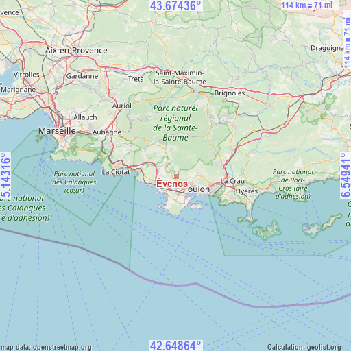
Évenos GPS coordinates[2]
43° 9' 49.14" North, 5° 50' 46.608" East
| Map corner | latitude | longitude |
|---|---|---|
| Upper-left | 43.67436°, | 5.14316° |
| Center: | 43.16365°, | 5.84628° |
| Lower-right: | 42.64864°, | 6.54941° |
| Map W x H: | 114×114 km | = 70.8×70.8mi |
| max Lat: | 51.07786° ⇑97.5% North |
| Évenos: | 43.16365° |
| min Lat: | ⇓2.5% South 41.3874° |
| min Long | Évenos | max Long |
| -5.08615° | 5.84628° | 9.52242° |
| W 85.5%⇐ | ⇒14.5% E |
Elevation
Elevation of Évenos is 271 m = 889 ft, and this is 77.3 m = 254 ft above average elevation for this country.
| Max E: |
2333 m = 7654 ft | 22.1% |
| Évenos | 271 m 889 ft | |
| Avg. | 193.7 m = 635 ft | |
Min E: |
-1 m = -3 ft | 77.9% |
See also: France elevation on elevation.city.
Geographical zone
Évenos is located in North temperate zone (between Tropic of Cancer and the Arctic Circle). Distance of this Northern Tropic circle is 2193.4 km =1362.9 mi to South.| Distance of | km | miles | from Évenos |
|---|---|---|---|
| North Pole | 5207.7 | 3235.9 | to North |
| Arctic Circle | 2601.8 | 1616.7 | to North |
| Tropic Cancer | 2193.4 | 1362.9 | to South |
| Equator | 4799.3 | 2982.1 | to South |


Nearby cities:
15 places around Évenos: (largest is in red/bold)
• Bandol
8.4 km =5.2 mi,  253°
253°
• La Garde
14 km =8.7 mi,  108°
108°
• La Seyne-sur-Mer
7.2 km =4.5 mi,  158°
158°
• La Valette-du-Var
11.5 km =7.1 mi,  104°
104°
• Le Beausset
5.2 km =3.2 mi,  317°
317°
• Le Castellet
7.1 km =4.4 mi,  307°
307°
• Le Revest-les-Eaux
6.7 km =4.2 mi,  77°
77°
• Ollioules
2.6 km =1.6 mi,  177°
177°
• Saint-Cyr-sur-Mer
11.9 km =7.4 mi,  279°
279°
• Saint-Mandrier-sur-Mer
11.7 km =7.3 mi,  144°
144°
• Sanary-sur-Mer
6.1 km =3.8 mi,  216°
216°
• Signes
14.2 km =8.8 mi,  5°
5°
• Six-Fours-les-Plages
8.2 km =5.1 mi,  192°
192°
• Solliès-Toucas
15.2 km =9.4 mi,  72°
72°
• Toulon
8 km =5 mi,  123°
123°
Sources, notices
• [Note1] Compared only with cities in France existing in our database
• [Src1] Map data: © OpenStreetMap contributors (CC-BY-SA)
• [Src2] Other city data from geonames.org with taken over terms of usage.
• [Src3] Geographical zone / Annual Mean Temperature by Robert A. Rohde @ Wikipedia
