Sanary-sur-Mer geodata
Sanary-sur-Mer (Provence-Alpes-Côte d'Azur) is a populated place; located in France in Europe/Paris (GMT+2) time zone. With population of 19,166 people, there are 480 cities with bigger population in this country. Compared to other cities in France, 97.8% of cities are located further ↑North; 85.2% of cities are located further ←West and 97.4% of cities have higher elevation than Sanary-sur-Mer. Note1
Administrative division(s):
- Level 1: Provence-Alpes-Côte d'Azur
- Level 2: Var
- Level 3: Arrondissement de Toulon
- Level 4: Sanary-sur-Mer


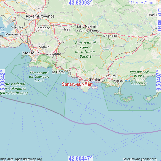
Sanary-sur-Mer GPS coordinates[2]
43° 7' 11.46" North, 5° 48' 5.58" East
| Map corner | latitude | longitude |
|---|---|---|
| Upper-left | 43.63093°, | 5.09842° |
| Center: | 43.11985°, | 5.80155° |
| Lower-right: | 42.60447°, | 6.50467° |
| Map W x H: | 114.1×114.1 km | = 70.9×70.9mi |
| max Lat: | 51.07786° ⇑97.8% North |
| Sanary-sur-Mer: | 43.11985° |
| min Lat: | ⇓2.2% South 41.3874° |
| min Long | Sanary-sur-Mer | max Long |
| -5.08615° | 5.80155° | 9.52242° |
| W 85.2%⇐ | ⇒14.8% E |
Elevation
Elevation of Sanary-sur-Mer is 10 m = 33 ft, and this is 183.7 m = 603 ft below average elevation for this country.
| Max E: |
2333 m = 7654 ft | 97.4% |
| Avg. | 193.7 m = 635 ft | |
| Sanary-sur-Mer | 10 m = 33 ft | |
Min E: |
-1 m = -3 ft | 2.6% |
See also: France elevation on elevation.city.
Geographical zone
Sanary-sur-Mer is located in North temperate zone (between Tropic of Cancer and the Arctic Circle). Distance of this Northern Tropic circle is 2188.6 km =1359.9 mi to South.| Distance of | km | miles | from Sanary-sur-Mer |
|---|---|---|---|
| North Pole | 5212.6 | 3239 | to North |
| Arctic Circle | 2606.7 | 1619.7 | to North |
| Tropic Cancer | 2188.6 | 1359.9 | to South |
| Equator | 4794.5 | 2979.2 | to South |


Nearby cities:
15 places around Sanary-sur-Mer: (largest is in red/bold)
• Bandol
5.1 km =3.2 mi,  299°
299°
• Ceyreste
17.4 km =10.8 mi,  306°
306°
• La Ciotat
17.1 km =10.6 mi,  290°
290°
• La Garde
17 km =10.6 mi,  88°
88°
• La Seyne-sur-Mer
6.5 km =4 mi,  106°
106°
• La Valette-du-Var
14.9 km =9.3 mi,  82°
82°
• Le Beausset
8.7 km =5.4 mi,  0°
0°
• Le Castellet
9.5 km =5.9 mi,  347°
347°
• Le Revest-les-Eaux
11.9 km =7.4 mi,  58°
58°
• Ollioules
4.4 km =2.7 mi, 59°
• Saint-Cyr-sur-Mer
10.6 km =6.6 mi, 309°
• Saint-Mandrier-sur-Mer
11.3 km =7 mi, 114°
• Six-Fours-les-Plages
3.6 km =2.2 mi,  149°
149°
• Toulon
10.3 km =6.4 mi, 87°
• Évenos
6.1 km =3.8 mi,  36°
36°
Sources, notices
• [Note1] Compared only with cities in France existing in our database
• [Src1] Map data: © OpenStreetMap contributors (CC-BY-SA)
• [Src2] Other city data from geonames.org with taken over terms of usage.
• [Src3] Geographical zone / Annual Mean Temperature by Robert A. Rohde @ Wikipedia
