Sucy-en-Brie geodata
Sucy-en-Brie (Île-de-France) is a populated place; located in France in Europe/Paris (GMT+2) time zone. With population of 25,014 people, there are 345 cities with bigger population in this country. Compared to other cities in France, 74.8% of cities are located further ↓South; 51.1% of cities are located further ←West and 62% of cities have higher elevation than Sucy-en-Brie. Note1
Administrative division(s):
- Level 1: Île-de-France
- Level 2: Val-de-Marne
- Level 3: Arrondissement de Créteil
- Level 4: Sucy-en-Brie


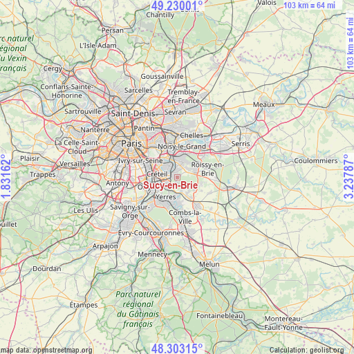
Sucy-en-Brie GPS coordinates[2]
48° 46' 7.392" North, 2° 32' 5.064" East
| Map corner | latitude | longitude |
|---|---|---|
| Upper-left | 49.23001°, | 1.83162° |
| Center: | 48.76872°, | 2.53474° |
| Lower-right: | 48.30315°, | 3.23787° |
| Map W x H: | 103.1×103.1 km | = 64.1×64.1mi |
| max Lat: | 51.07786° ⇑25.2% North |
| Sucy-en-Brie: | 48.76872° |
| min Lat: | ⇓74.8% South 41.3874° |
| min Long | Sucy-en-Brie | max Long |
| -5.08615° | 2.53474° | 9.52242° |
| W 51.1%⇐ | ⇒48.9% E |
Elevation
Elevation of Sucy-en-Brie is 97 m = 318 ft, and this is 96.7 m = 317 ft below average elevation for this country.
| Max E: |
2333 m = 7654 ft | 62% |
| Avg. | 193.7 m = 635 ft | |
| Sucy-en-Brie | 97 m = 318 ft | |
Min E: |
-1 m = -3 ft | 38% |
See also: France elevation on elevation.city.
Geographical zone
Sucy-en-Brie is located in North temperate zone (between Tropic of Cancer and the Arctic Circle). Distance of this North polar circle is 1978.6 km =1229.4 mi to North.| Distance of | km | miles | from Sucy-en-Brie |
|---|---|---|---|
| North Pole | 4584.5 | 2848.7 | to North |
| Arctic Circle | 1978.6 | 1229.4 | to North |
| Tropic Cancer | 2816.7 | 1750.2 | to South |
| Equator | 5422.6 | 3369.4 | to South |


Nearby cities:
15 places around Sucy-en-Brie: (largest is in red/bold)
• Boissy-Saint-Léger
2.6 km =1.6 mi,  221°
221°
• Bonneuil-sur-Marne
4.1 km =2.5 mi,  271°
271°
• Champigny-sur-Marne
6.1 km =3.8 mi,  330°
330°
• Chennevières-sur-Marne
3.2 km =2 mi,  7°
7°
• Créteil
5.7 km =3.5 mi,  297°
297°
• La Queue-en-Brie
3.9 km =2.4 mi,  61°
61°
• Le Plessis-Trévise
5.5 km =3.4 mi,  31°
31°
• Limeil-Brévannes
4.4 km =2.7 mi,  232°
232°
• Noiseau
1.3 km =0.8 mi,  52°
52°
• Ormesson-sur-Marne
2.1 km =1.3 mi,  20°
20°
• Pontault-Combault
6.2 km =3.9 mi, 58°
• Saint-Maur-des-Fossés
4.1 km =2.5 mi,  312°
312°
• Santeny
5.4 km =3.4 mi,  148°
148°
• Valenton
5.8 km =3.6 mi,  243°
243°
• Villecresnes
5.4 km =3.4 mi,  176°
176°
Sources, notices
• [Note1] Compared only with cities in France existing in our database
• [Src1] Map data: © OpenStreetMap contributors (CC-BY-SA)
• [Src2] Other city data from geonames.org with taken over terms of usage.
• [Src3] Geographical zone / Annual Mean Temperature by Robert A. Rohde @ Wikipedia
