Garencières geodata
Garencières (Normandy) is a populated place; located in France in Europe/Paris (GMT+2) time zone. With population of 522 people, there are 14782 cities with bigger population in this country. Compared to other cities in France, 78.7% of cities are located further ↓South; 66% of cities are located further →East and 53.6% of cities have lower elevation than Garencières. Note1
Administrative division(s):
- Level 1: Normandy
- Level 2: Département de l'Eure
- Level 3: Arrondissement d’Évreux
- Level 4: La Baronnie


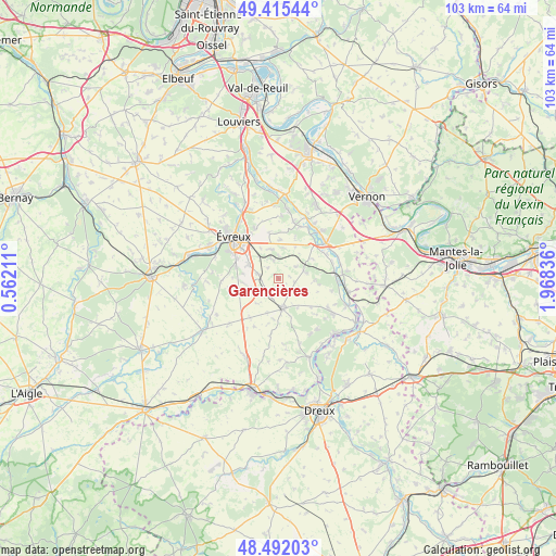
Garencières GPS coordinates[2]
48° 57' 21.132" North, 1° 15' 54.828" East
| Map corner | latitude | longitude |
|---|---|---|
| Upper-left | 49.41544°, | 0.56211° |
| Center: | 48.95587°, | 1.26523° |
| Lower-right: | 48.49203°, | 1.96836° |
| Map W x H: | 102.7×102.7 km | = 63.8×63.8mi |
| max Lat: | 51.07786° ⇑21.3% North |
| Garencières: | 48.95587° |
| min Lat: | ⇓78.7% South 41.3874° |
| min Long | Garencières | max Long |
| -5.08615° | 1.26523° | 9.52242° |
| W 34%⇐ | ⇒66% E |
Elevation
Elevation of Garencières is 145 m = 476 ft, and this is 48.7 m = 160 ft below average elevation for this country.
| Max E: |
2333 m = 7654 ft | 46.4% |
| Avg. | 193.7 m = 635 ft | |
| Garencières | 145 m = 476 ft | |
Min E: |
-1 m = -3 ft | 53.6% |
See also: France elevation on elevation.city.
Geographical zone
Garencières is located in North temperate zone (between Tropic of Cancer and the Arctic Circle). Distance of this North polar circle is 1957.8 km =1216.5 mi to North.| Distance of | km | miles | from Garencières |
|---|---|---|---|
| North Pole | 4563.7 | 2835.8 | to North |
| Arctic Circle | 1957.8 | 1216.5 | to North |
| Tropic Cancer | 2837.5 | 1763.1 | to South |
| Equator | 5443.4 | 3382.4 | to South |


Nearby cities:
15 places around Garencières: (largest is in red/bold)
• Cierrey
5.7 km =3.5 mi,  8°
8°
• Gauciel
8.7 km =5.4 mi,  348°
348°
• Guichainville
7.3 km =4.5 mi,  313°
313°
• Huest
10.2 km =6.3 mi,  334°
334°
• Jouy-sur-Eure
11 km =6.8 mi, 13°
• Le Plessis-Grohan
9.7 km =6 mi,  264°
264°
• Le Val-David
3.2 km =2 mi,  339°
339°
• Le Vieil-Évreux
5.8 km =3.6 mi, 339°
• Miserey
7.3 km =4.5 mi,  2°
2°
• Mouettes
9.6 km =6 mi,  133°
133°
• Mousseaux-Neuville
8 km =5 mi, 131°
• Pacy-sur-Eure
11 km =6.8 mi,  51°
51°
• Prey
4.2 km =2.6 mi,  281°
281°
• Saint-Aquilin-de-Pacy
9.4 km =5.8 mi, 48°
• Évreux
11.3 km =7 mi, 312°
Sources, notices
• [Note1] Compared only with cities in France existing in our database
• [Src1] Map data: © OpenStreetMap contributors (CC-BY-SA)
• [Src2] Other city data from geonames.org with taken over terms of usage.
• [Src3] Geographical zone / Annual Mean Temperature by Robert A. Rohde @ Wikipedia
