Le Plessis-Belleville geodata
Le Plessis-Belleville (Hauts-de-France) is a populated place; located in France in Europe/Paris (GMT+2) time zone. With population of 3,120 people, there are 3125 cities with bigger population in this country. Compared to other cities in France, 82% of cities are located further ↓South; 54.3% of cities are located further ←West and 55.6% of cities have higher elevation than Le Plessis-Belleville. Note1
Administrative division(s):
- Level 1: Hauts-de-France
- Level 2: Département de l'Oise
- Level 3: Arrondissement de Senlis
- Level 4: Le Plessis-Belleville
Current local time in Le Plessis-Belleville:
04:55 AM, SaturdayDifference from your time zone: hours


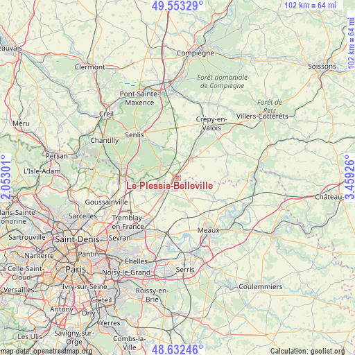
Le Plessis-Belleville GPS coordinates[2]
49° 5' 42.036" North, 2° 45' 22.104" East
| Map corner | latitude | longitude |
|---|---|---|
| Upper-left | 49.55329°, | 2.05301° |
| Center: | 49.09501°, | 2.75614° |
| Lower-right: | 48.63246°, | 3.45926° |
| Map W x H: | 102.4×102.4 km | = 63.6×63.6mi |
| max Lat: | 51.07786° ⇑18% North |
| Le Plessis-Belleville: | 49.09501° |
| min Lat: | ⇓82% South 41.3874° |
| min Long | Le Plessis-Bell | max Long |
| -5.08615° | 2.75614° | 9.52242° |
| W 54.3%⇐ | ⇒45.7% E |
Elevation
Elevation of Le Plessis-Belleville is 115 m = 377 ft, and this is 78.7 m = 258 ft below average elevation for this country.
| Max E: |
2333 m = 7654 ft | 55.6% |
| Avg. | 193.7 m = 635 ft | |
| Le Plessis-Belleville | 115 m = 377 ft | |
Min E: |
-1 m = -3 ft | 44.4% |
See also: France elevation on elevation.city.
Geographical zone
Le Plessis-Belleville is located in North temperate zone (between Tropic of Cancer and the Arctic Circle). Distance of this North polar circle is 1942.3 km =1206.9 mi to North.| Distance of | km | miles | from Le Plessis-Belleville |
|---|---|---|---|
| North Pole | 4548.2 | 2826.1 | to North |
| Arctic Circle | 1942.3 | 1206.9 | to North |
| Tropic Cancer | 2852.9 | 1772.7 | to South |
| Equator | 5458.9 | 3392 | to South |


Nearby cities:
15 places around Le Plessis-Belleville: (largest is in red/bold)
• Brégy
8.1 km =5 mi,  100°
100°
• Dammartin-en-Goële
7.3 km =4.5 mi,  231°
231°
• Ermenonville
5.5 km =3.4 mi,  309°
309°
• Lagny-le-Sec
1.2 km =0.7 mi,  223°
223°
• Longperrier
8.4 km =5.2 mi, 231°
• Montgé-en-Goële
6.9 km =4.3 mi,  183°
183°
• Nanteuil-le-Haudouin
6.5 km =4 mi,  38°
38°
• Oissery
5.3 km =3.3 mi,  121°
121°
• Othis
6.4 km =4 mi,  248°
248°
• Rouvres
4.6 km =2.9 mi, 218°
• Saint-Mard
7.8 km =4.8 mi,  213°
213°
• Saint-Pathus
4.1 km =2.5 mi,  130°
130°
• Saint-Soupplets
7.3 km =4.5 mi,  149°
149°
• Silly-le-Long
3 km =1.9 mi,  62°
62°
• Ver-sur-Launette
5.4 km =3.4 mi,  281°
281°
Sources, notices
• [Note1] Compared only with cities in France existing in our database
• [Src1] Map data: © OpenStreetMap contributors (CC-BY-SA)
• [Src2] Other city data from geonames.org with taken over terms of usage.
• [Src3] Geographical zone / Annual Mean Temperature by Robert A. Rohde @ Wikipedia
