Ermenonville geodata
Ermenonville (Hauts-de-France) is a populated place; located in France in Europe/Paris (GMT+2) time zone. With population of 864 people, there are 9950 cities with bigger population in this country. Compared to other cities in France, 82.8% of cities are located further ↓South; 53.4% of cities are located further ←West and 64% of cities have higher elevation than Ermenonville. Note1
Administrative division(s):
- Level 1: Hauts-de-France
- Level 2: Département de l'Oise
- Level 3: Arrondissement de Senlis
- Level 4: Ermenonville


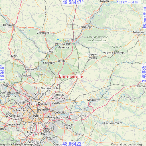
Ermenonville GPS coordinates[2]
49° 7' 35.328" North, 2° 41' 51.792" East
| Map corner | latitude | longitude |
|---|---|---|
| Upper-left | 49.58447°, | 1.9946° |
| Center: | 49.12648°, | 2.69772° |
| Lower-right: | 48.66422°, | 3.40085° |
| Map W x H: | 102.3×102.3 km | = 63.6×63.6mi |
| max Lat: | 51.07786° ⇑17.2% North |
| Ermenonville: | 49.12648° |
| min Lat: | ⇓82.8% South 41.3874° |
| min Long | Ermenonville | max Long |
| -5.08615° | 2.69772° | 9.52242° |
| W 53.4%⇐ | ⇒46.6% E |
Elevation
Elevation of Ermenonville is 92 m = 302 ft, and this is 101.7 m = 334 ft below average elevation for this country.
| Max E: |
2333 m = 7654 ft | 64% |
| Avg. | 193.7 m = 635 ft | |
| Ermenonville | 92 m = 302 ft | |
Min E: |
-1 m = -3 ft | 36% |
See also: France elevation on elevation.city.
Geographical zone
Ermenonville is located in North temperate zone (between Tropic of Cancer and the Arctic Circle). Distance of this North polar circle is 1938.8 km =1204.7 mi to North.| Distance of | km | miles | from Ermenonville |
|---|---|---|---|
| North Pole | 4544.7 | 2823.9 | to North |
| Arctic Circle | 1938.8 | 1204.7 | to North |
| Tropic Cancer | 2856.4 | 1774.9 | to South |
| Equator | 5462.4 | 3394.2 | to South |


Nearby cities:
15 places around Ermenonville: (largest is in red/bold)
• Baron
5.7 km =3.5 mi,  24°
24°
• Dammartin-en-Goële
8.2 km =5.1 mi,  190°
190°
• Lagny-le-Sec
5.5 km =3.4 mi,  141°
141°
• Le Plessis-Belleville
5.5 km =3.4 mi,  129°
129°
• Longperrier
9 km =5.6 mi,  195°
195°
• Moussy-le-Neuf
9.8 km =6.1 mi,  225°
225°
• Nanteuil-le-Haudouin
8.4 km =5.2 mi,  79°
79°
• Othis
6.1 km =3.8 mi, 195°
• Plailly
8.6 km =5.3 mi,  252°
252°
• Rouvres
7.3 km =4.5 mi,  168°
168°
• Saint-Mard
9.9 km =6.2 mi,  180°
180°
• Saint-Pathus
9.6 km =6 mi, 129°
• Silly-le-Long
7.2 km =4.5 mi,  107°
107°
• Thiers-sur-Thève
9.7 km =6 mi,  287°
287°
• Ver-sur-Launette
2.6 km =1.6 mi, 202°
Sources, notices
• [Note1] Compared only with cities in France existing in our database
• [Src1] Map data: © OpenStreetMap contributors (CC-BY-SA)
• [Src2] Other city data from geonames.org with taken over terms of usage.
• [Src3] Geographical zone / Annual Mean Temperature by Robert A. Rohde @ Wikipedia
