Lens geodata
Lens (Hauts-de-France) is a seat of a third-order administrative division; located in France in Europe/Paris (GMT+2) time zone. With population of 38,265 people, there are 198 cities with bigger population in this country. Compared to other cities in France, 96.7% of cities are located further ↓South; 55.4% of cities are located further ←West and 87.1% of cities have higher elevation than Lens. Note1
Administrative division(s):
- Level 1: Hauts-de-France
- Level 2: Pas-de-Calais
- Level 3: Arrondissement de Lens
- Level 4: Lens


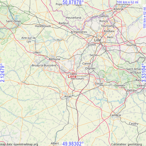
Lens GPS coordinates[2]
50° 25' 58.872" North, 2° 49' 40.476" East
| Map corner | latitude | longitude |
|---|---|---|
| Upper-left | 50.87878°, | 2.12479° |
| Center: | 50.43302°, | 2.82791° |
| Lower-right: | 49.98302°, | 3.53104° |
| Map W x H: | 99.6×99.6 km | = 61.9×61.9mi |
| max Lat: | 51.07786° ⇑3.3% North |
| Lens: | 50.43302° |
| min Lat: | ⇓96.7% South 41.3874° |
| min Long | Lens | max Long |
| -5.08615° | 2.82791° | 9.52242° |
| W 55.4%⇐ | ⇒44.6% E |
Elevation
Elevation of Lens is 37 m = 121 ft, and this is 156.7 m = 514 ft below average elevation for this country.
| Max E: |
2333 m = 7654 ft | 87.1% |
| Avg. | 193.7 m = 635 ft | |
| Lens | 37 m = 121 ft | |
Min E: |
-1 m = -3 ft | 12.9% |
See also: France elevation on elevation.city.
Geographical zone
Lens is located in North temperate zone (between Tropic of Cancer and the Arctic Circle). Distance of this North polar circle is 1793.5 km =1114.4 mi to North.| Distance of | km | miles | from Lens |
|---|---|---|---|
| North Pole | 4399.4 | 2733.7 | to North |
| Arctic Circle | 1793.5 | 1114.4 | to North |
| Tropic Cancer | 3001.7 | 1865.2 | to South |
| Equator | 5607.6 | 3484.4 | to South |


Nearby cities:
15 places around Lens: (largest is in red/bold)
• Angres
5.7 km =3.5 mi,  237°
237°
• Annay
5 km =3.1 mi,  48°
48°
• Avion
2.5 km =1.6 mi,  175°
175°
• Billy-Montigny
5.6 km =3.5 mi,  108°
108°
• Fouquières-lès-Lens
6.1 km =3.8 mi,  94°
94°
• Grenay
5.7 km =3.5 mi,  288°
288°
• Harnes
5.6 km =3.5 mi,  74°
74°
• Liévin
3.7 km =2.3 mi,  246°
246°
• Loison-sous-Lens
1.9 km =1.2 mi, 72°
• Loos-en-Gohelle
3.7 km =2.3 mi,  317°
317°
• Méricourt
4.3 km =2.7 mi,  145°
145°
• Noyelles-sous-Lens
3.1 km =1.9 mi, 94°
• Sallaumines
3 km =1.9 mi,  125°
125°
• Vendin-le-Vieil
5.3 km =3.3 mi,  31°
31°
• Éleu-dit-Leauwette
1.8 km =1.1 mi,  223°
223°
Sources, notices
• [Note1] Compared only with cities in France existing in our database
• [Src1] Map data: © OpenStreetMap contributors (CC-BY-SA)
• [Src2] Other city data from geonames.org with taken over terms of usage.
• [Src3] Geographical zone / Annual Mean Temperature by Robert A. Rohde @ Wikipedia
