Grenay geodata
Grenay (Hauts-de-France) is a populated place; located in France in Europe/Paris (GMT+2) time zone. With population of 6,491 people, there are 1520 cities with bigger population in this country. Compared to other cities in France, 96.9% of cities are located further ↓South; 54.3% of cities are located further ←West and 75% of cities have higher elevation than Grenay. Note1
Administrative division(s):
- Level 1: Hauts-de-France
- Level 2: Pas-de-Calais
- Level 3: Arrondissement de Lens
- Level 4: Grenay


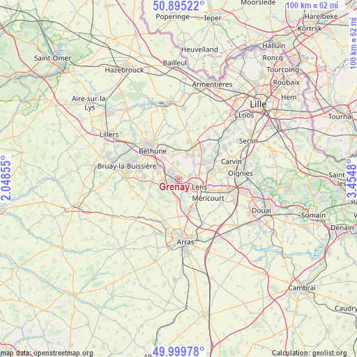
Grenay GPS coordinates[2]
50° 26' 58.632" North, 2° 45' 6.048" East
| Map corner | latitude | longitude |
|---|---|---|
| Upper-left | 50.89522°, | 2.04855° |
| Center: | 50.44962°, | 2.75168° |
| Lower-right: | 49.99978°, | 3.4548° |
| Map W x H: | 99.6×99.6 km | = 61.9×61.9mi |
| max Lat: | 51.07786° ⇑3.1% North |
| Grenay: | 50.44962° |
| min Lat: | ⇓96.9% South 41.3874° |
| min Long | Grenay | max Long |
| -5.08615° | 2.75168° | 9.52242° |
| W 54.3%⇐ | ⇒45.7% E |
Elevation
Elevation of Grenay is 67 m = 220 ft, and this is 126.7 m = 416 ft below average elevation for this country.
| Max E: |
2333 m = 7654 ft | 75% |
| Avg. | 193.7 m = 635 ft | |
| Grenay | 67 m = 220 ft | |
Min E: |
-1 m = -3 ft | 25% |
See also: France elevation on elevation.city.
Geographical zone
Grenay is located in North temperate zone (between Tropic of Cancer and the Arctic Circle). Distance of this North polar circle is 1791.7 km =1113.3 mi to North.| Distance of | km | miles | from Grenay |
|---|---|---|---|
| North Pole | 4397.6 | 2732.5 | to North |
| Arctic Circle | 1791.7 | 1113.3 | to North |
| Tropic Cancer | 3003.6 | 1866.3 | to South |
| Equator | 5609.5 | 3485.6 | to South |


Nearby cities:
15 places around Grenay: (largest is in red/bold)
• Aix-Noulette
4.2 km =2.6 mi,  230°
230°
• Angres
4.9 km =3 mi,  172°
172°
• Annequin
6.6 km =4.1 mi,  340°
340°
• Bouvigny-Boyeffles
6.4 km =4 mi,  240°
240°
• Bully-les-Mines
1.9 km =1.2 mi,  249°
249°
• Hulluch
6.2 km =3.9 mi,  43°
43°
• Lens
5.7 km =3.5 mi,  108°
108°
• Liévin
3.9 km =2.4 mi,  148°
148°
• Loos-en-Gohelle
3 km =1.9 mi,  72°
72°
• Mazingarbe
3.5 km =2.2 mi,  312°
312°
• Noyelles-lès-Vermelles
4.8 km =3 mi, 338°
• Sains-en-Gohelle
4.9 km =3 mi,  264°
264°
• Souchez
6.4 km =4 mi,  187°
187°
• Vermelles
4.4 km =2.7 mi,  356°
356°
• Éleu-dit-Leauwette
5.2 km =3.2 mi,  126°
126°
Sources, notices
• [Note1] Compared only with cities in France existing in our database
• [Src1] Map data: © OpenStreetMap contributors (CC-BY-SA)
• [Src2] Other city data from geonames.org with taken over terms of usage.
• [Src3] Geographical zone / Annual Mean Temperature by Robert A. Rohde @ Wikipedia
