Lencloître geodata
Lencloître (Nouvelle-Aquitaine) is a populated place; located in France in Europe/Paris (GMT+2) time zone. With population of 2,397 people, there are 4040 cities with bigger population in this country. Compared to other cities in France, 57.1% of cities are located further ↑North; 75.1% of cities are located further →East and 71.4% of cities have higher elevation than Lencloître. Note1
Administrative division(s):
- Level 1: Nouvelle-Aquitaine
- Level 2: Vienne
- Level 3: Arrondissement de Châtellerault
- Level 4: Lencloître


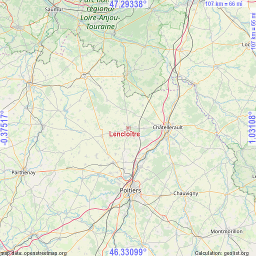
Lencloître GPS coordinates[2]
46° 48' 51.624" North, 0° 19' 40.656" East
| Map corner | latitude | longitude |
|---|---|---|
| Upper-left | 47.29338°, | -0.37517° |
| Center: | 46.81434°, | 0.32796° |
| Lower-right: | 46.33099°, | 1.03108° |
| Map W x H: | 107×107 km | = 66.5×66.5mi |
| max Lat: | 51.07786° ⇑57.1% North |
| Lencloître: | 46.81434° |
| min Lat: | ⇓42.9% South 41.3874° |
| min Long | Lencloître | max Long |
| -5.08615° | 0.32796° | 9.52242° |
| W 24.9%⇐ | ⇒75.1% E |
Elevation
Elevation of Lencloître is 75 m = 246 ft, and this is 118.7 m = 389 ft below average elevation for this country.
| Max E: |
2333 m = 7654 ft | 71.4% |
| Avg. | 193.7 m = 635 ft | |
| Lencloître | 75 m = 246 ft | |
Min E: |
-1 m = -3 ft | 28.6% |
See also: France elevation on elevation.city.
Geographical zone
Lencloître is located in North temperate zone (between Tropic of Cancer and the Arctic Circle). Distance of this North polar circle is 2195.9 km =1364.5 mi to North.| Distance of | km | miles | from Lencloître |
|---|---|---|---|
| North Pole | 4801.8 | 2983.7 | to North |
| Arctic Circle | 2195.9 | 1364.5 | to North |
| Tropic Cancer | 2599.3 | 1615.1 | to South |
| Equator | 5205.3 | 3234.4 | to South |


Nearby cities:
15 places around Lencloître: (largest is in red/bold)
• Beaumont
11.6 km =7.2 mi,  138°
138°
• Chabournay
12.1 km =7.5 mi,  206°
206°
• Chouppes
12.5 km =7.8 mi,  268°
268°
• Colombiers
8.7 km =5.4 mi,  122°
122°
• Doussay
5.2 km =3.2 mi,  308°
308°
• Marigny-Brizay
8.4 km =5.2 mi,  153°
153°
• Mirebeau
11.6 km =7.2 mi,  253°
253°
• Monts-sur-Guesnes
14.6 km =9.1 mi,  322°
322°
• Naintré
13.1 km =8.1 mi, 115°
• Saint-Cyr
13.7 km =8.5 mi, 140°
• Saint-Gervais-les-Trois-Clochers
11.3 km =7 mi,  32°
32°
• Scorbé-Clairvaux
6.5 km =4 mi,  91°
91°
• Thurageau
8.3 km =5.2 mi,  232°
232°
• Thuré
10.2 km =6.3 mi,  79°
79°
• Vendeuvre-du-Poitou
8.9 km =5.5 mi,  189°
189°
Sources, notices
• [Note1] Compared only with cities in France existing in our database
• [Src1] Map data: © OpenStreetMap contributors (CC-BY-SA)
• [Src2] Other city data from geonames.org with taken over terms of usage.
• [Src3] Geographical zone / Annual Mean Temperature by Robert A. Rohde @ Wikipedia
