Le Grau-du-Roi geodata
Le Grau-du-Roi (Occitanie) is a populated place; located in France in Europe/Paris (GMT+2) time zone. With population of 6,368 people, there are 1555 cities with bigger population in this country. Compared to other cities in France, 92.6% of cities are located further ↑North; 69.1% of cities are located further ←West and 99.8% of cities have higher elevation than Le Grau-du-Roi. Note1
Administrative division(s):
- Level 1: Occitanie
- Level 2: Gard
- Level 3: Arrondissement de Nîmes
- Level 4: Le Grau-du-Roi


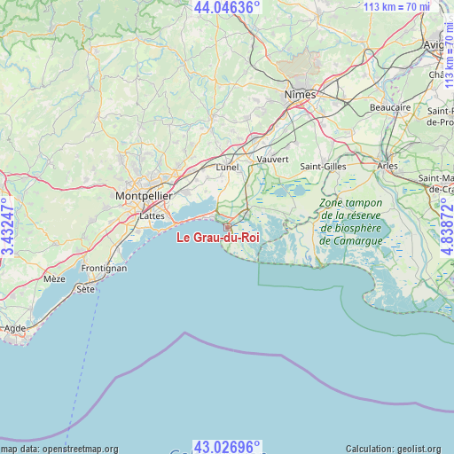
Le Grau-du-Roi GPS coordinates[2]
43° 32' 19.716" North, 4° 8' 8.124" East
| Map corner | latitude | longitude |
|---|---|---|
| Upper-left | 44.04636°, | 3.43247° |
| Center: | 43.53881°, | 4.13559° |
| Lower-right: | 43.02696°, | 4.83872° |
| Map W x H: | 113.3×113.3 km | = 70.4×70.4mi |
| max Lat: | 51.07786° ⇑92.6% North |
| Le Grau-du-Roi: | 43.53881° |
| min Lat: | ⇓7.4% South 41.3874° |
| min Long | Le Grau-du-Roi | max Long |
| -5.08615° | 4.13559° | 9.52242° |
| W 69.1%⇐ | ⇒30.9% E |
Elevation
Elevation of Le Grau-du-Roi is 3 m = 10 ft, and this is 190.7 m = 626 ft below average elevation for this country.
| Max E: |
2333 m = 7654 ft | 99.8% |
| Avg. | 193.7 m = 635 ft | |
| Le Grau-du-Roi | 3 m = 10 ft | |
Min E: |
-1 m = -3 ft | 0.2% |
See also: France elevation on elevation.city.
Geographical zone
Le Grau-du-Roi is located in North temperate zone (between Tropic of Cancer and the Arctic Circle). Distance of this Northern Tropic circle is 2235.1 km =1388.8 mi to South.| Distance of | km | miles | from Le Grau-du-Roi |
|---|---|---|---|
| North Pole | 5166 | 3210 | to North |
| Arctic Circle | 2560.1 | 1590.8 | to North |
| Tropic Cancer | 2235.1 | 1388.8 | to South |
| Equator | 4841.1 | 3008.1 | to South |


Nearby cities:
15 places around Le Grau-du-Roi: (largest is in red/bold)
• Aigues-Mortes
5.4 km =3.4 mi,  54°
54°
• Baillargues
16.8 km =10.4 mi,  325°
325°
• Candillargues
10.5 km =6.5 mi, 329°
• La Grande-Motte
5.2 km =3.2 mi,  306°
306°
• Lansargues
13.5 km =8.4 mi,  338°
338°
• Lunel
15.5 km =9.6 mi,  0°
0°
• Lunel-Viel
16 km =9.9 mi,  347°
347°
• Marsillargues
14.3 km =8.9 mi,  12°
12°
• Mauguio
13.6 km =8.5 mi, 310°
• Mudaison
13.4 km =8.3 mi,  321°
321°
• Pérols
15 km =9.3 mi,  280°
280°
• Saint-Brès
16.6 km =10.3 mi, 329°
• Saint-Just
13.4 km =8.3 mi, 352°
• Saint-Nazaire-de-Pézan
11.8 km =7.3 mi, 353°
• Valergues
15.6 km =9.7 mi, 337°
Sources, notices
• [Note1] Compared only with cities in France existing in our database
• [Src1] Map data: © OpenStreetMap contributors (CC-BY-SA)
• [Src2] Other city data from geonames.org with taken over terms of usage.
• [Src3] Geographical zone / Annual Mean Temperature by Robert A. Rohde @ Wikipedia
