Saint-Léger-Magnazeix geodata
Saint-Léger-Magnazeix (Nouvelle-Aquitaine) is a populated place; located in France in Europe/Paris (GMT+2) time zone. With population of 566 people, there are 13895 cities with bigger population in this country. Compared to other cities in France, 62.5% of cities are located further ↑North; 66.1% of cities are located further →East and 75.6% of cities have lower elevation than Saint-Léger-Magnazeix. Note1
Administrative division(s):
- Level 1: Nouvelle-Aquitaine
- Level 2: Haute-Vienne
- Level 3: Arrondissement de Bellac
- Level 4: Saint-Léger-Magnazeix
Current local time in Saint-Léger-Magnazeix:
09:15 AM, SaturdayDifference from your time zone: hours


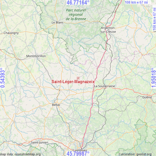
Saint-Léger-Magnazeix GPS coordinates[2]
46° 17' 16.476" North, 1° 14' 49.38" East
| Map corner | latitude | longitude |
|---|---|---|
| Upper-left | 46.77164°, | 0.54393° |
| Center: | 46.28791°, | 1.24705° |
| Lower-right: | 45.79987°, | 1.95018° |
| Map W x H: | 108.1×10⁸ km | = 67.2×67.1mi |
| max Lat: | 51.07786° ⇑62.5% North |
| Saint-Léger-Magnazeix: | 46.28791° |
| min Lat: | ⇓37.5% South 41.3874° |
| min Long | Saint-Léger-Ma | max Long |
| -5.08615° | 1.24705° | 9.52242° |
| W 33.9%⇐ | ⇒66.1% E |
Elevation
Elevation of Saint-Léger-Magnazeix is 254 m = 833 ft, and this is 60.3 m = 198 ft above average elevation for this country.
| Max E: |
2333 m = 7654 ft | 24.4% |
| Saint-Léger-Magnazeix | 254 m 833 ft | |
| Avg. | 193.7 m = 635 ft | |
Min E: |
-1 m = -3 ft | 75.6% |
See also: France elevation on elevation.city.
Geographical zone
Saint-Léger-Magnazeix is located in North temperate zone (between Tropic of Cancer and the Arctic Circle). Distance of this North polar circle is 2254.4 km =1400.8 mi to North.| Distance of | km | miles | from Saint-Léger-Magnazeix |
|---|---|---|---|
| North Pole | 4860.3 | 3020 | to North |
| Arctic Circle | 2254.4 | 1400.8 | to North |
| Tropic Cancer | 2540.8 | 1578.8 | to South |
| Equator | 5146.7 | 3198 | to South |


Nearby cities:
15 places around Saint-Léger-Magnazeix: (largest is in red/bold)
• Arnac-la-Poste
10 km =6.2 mi,  104°
104°
• Azerables
18.9 km =11.7 mi,  67°
67°
• Brigueil-le-Chantre
17.1 km =10.6 mi,  314°
314°
• Chaillac
16.7 km =10.4 mi,  13°
13°
• Châteauponsac
17.2 km =10.7 mi,  172°
172°
• Fromental
18.4 km =11.4 mi,  140°
140°
• La Châtre-Langlin
17.3 km =10.7 mi,  39°
39°
• La Souterraine
19.2 km =11.9 mi,  106°
106°
• Le Dorat
15.1 km =9.4 mi,  237°
237°
• Lussac-les-Églises
8.5 km =5.3 mi,  318°
318°
• Magnac-Laval
10.2 km =6.3 mi,  217°
217°
• Rancon
18.2 km =11.3 mi,  195°
195°
• Saint-Maurice-la-Souterraine
16.3 km =10.1 mi,  120°
120°
• Saint-Sornin-Leulac
10.6 km =6.6 mi,  158°
158°
• Saint-Sulpice-les-Feuilles
9.9 km =6.2 mi, 69°
Sources, notices
• [Note1] Compared only with cities in France existing in our database
• [Src1] Map data: © OpenStreetMap contributors (CC-BY-SA)
• [Src2] Other city data from geonames.org with taken over terms of usage.
• [Src3] Geographical zone / Annual Mean Temperature by Robert A. Rohde @ Wikipedia
