Brigueil-le-Chantre geodata
Brigueil-le-Chantre (Nouvelle-Aquitaine) is a populated place; located in France in Europe/Paris (GMT+2) time zone. With population of 636 people, there are 12726 cities with bigger population in this country. Compared to other cities in France, 61.1% of cities are located further ↑North; 68% of cities are located further →East and 58% of cities have lower elevation than Brigueil-le-Chantre. Note1
Administrative division(s):
- Level 1: Nouvelle-Aquitaine
- Level 2: Vienne
- Level 3: Arrondissement de Montmorillon
- Level 4: Brigueil-le-Chantre


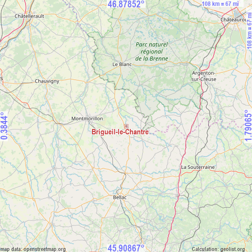
Brigueil-le-Chantre GPS coordinates[2]
46° 23' 44.7" North, 1° 5' 15.072" East
| Map corner | latitude | longitude |
|---|---|---|
| Upper-left | 46.87852°, | 0.3844° |
| Center: | 46.39575°, | 1.08752° |
| Lower-right: | 45.90867°, | 1.79065° |
| Map W x H: | 107.8×107.8 km | = 67×67mi |
| max Lat: | 51.07786° ⇑61.1% North |
| Brigueil-le-Chantre: | 46.39575° |
| min Lat: | ⇓38.9% South 41.3874° |
| min Long | Brigueil-le-Cha | max Long |
| -5.08615° | 1.08752° | 9.52242° |
| W 32%⇐ | ⇒68% E |
Elevation
Elevation of Brigueil-le-Chantre is 161 m = 528 ft, and this is 32.7 m = 107 ft below average elevation for this country.
| Max E: |
2333 m = 7654 ft | 42% |
| Avg. | 193.7 m = 635 ft | |
| Brigueil-le-Chantre | 161 m = 528 ft | |
Min E: |
-1 m = -3 ft | 58% |
See also: France elevation on elevation.city.
Geographical zone
Brigueil-le-Chantre is located in North temperate zone (between Tropic of Cancer and the Arctic Circle). Distance of this North polar circle is 2242.5 km =1393.4 mi to North.| Distance of | km | miles | from Brigueil-le-Chantre |
|---|---|---|---|
| North Pole | 4848.3 | 3012.6 | to North |
| Arctic Circle | 2242.5 | 1393.4 | to North |
| Tropic Cancer | 2552.8 | 1586.2 | to South |
| Equator | 5158.7 | 3205.5 | to South |


Nearby cities:
15 places around Brigueil-le-Chantre: (largest is in red/bold)
• Bussière-Poitevine
22.7 km =14.1 mi,  218°
218°
• Bélâbre
18.1 km =11.2 mi,  17°
17°
• Béthines
18.9 km =11.7 mi,  333°
333°
• Chaillac
16.7 km =10.4 mi,  75°
75°
• Concremiers
23 km =14.3 mi,  346°
346°
• La Trimouille
8.8 km =5.5 mi,  335°
335°
• Lathus-Saint-Rémy
12 km =7.5 mi,  235°
235°
• Le Dorat
20.2 km =12.6 mi,  181°
181°
• Lignac
12.7 km =7.9 mi,  52°
52°
• Lussac-les-Églises
8.7 km =5.4 mi,  130°
130°
• Magnac-Laval
21 km =13 mi,  163°
163°
• Montmorillon
17 km =10.6 mi,  281°
281°
• Prissac
21.2 km =13.2 mi, 53°
• Saint-Léger-Magnazeix
17.1 km =10.6 mi, 134°
• Saulgé
16.3 km =10.1 mi,  262°
262°
Sources, notices
• [Note1] Compared only with cities in France existing in our database
• [Src1] Map data: © OpenStreetMap contributors (CC-BY-SA)
• [Src2] Other city data from geonames.org with taken over terms of usage.
• [Src3] Geographical zone / Annual Mean Temperature by Robert A. Rohde @ Wikipedia
