Marguerittes geodata
Marguerittes (Occitanie) is a populated place; located in France in Europe/Paris (GMT+2) time zone. With population of 8,974 people, there are 1074 cities with bigger population in this country. Compared to other cities in France, 88.5% of cities are located further ↑North; 71.7% of cities are located further ←West and 80.6% of cities have higher elevation than Marguerittes. Note1
Administrative division(s):
- Level 1: Occitanie
- Level 2: Gard
- Level 3: Arrondissement de Nîmes
- Level 4: Marguerittes


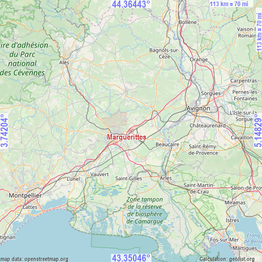
Marguerittes GPS coordinates[2]
43° 51' 34.56" North, 4° 26' 42.612" East
| Map corner | latitude | longitude |
|---|---|---|
| Upper-left | 44.36443°, | 3.74204° |
| Center: | 43.8596°, | 4.44517° |
| Lower-right: | 43.35046°, | 5.14829° |
| Map W x H: | 112.7×112.7 km | = 70×70mi |
| max Lat: | 51.07786° ⇑88.5% North |
| Marguerittes: | 43.8596° |
| min Lat: | ⇓11.5% South 41.3874° |
| min Long | Marguerittes | max Long |
| -5.08615° | 4.44517° | 9.52242° |
| W 71.7%⇐ | ⇒28.3% E |
Elevation
Elevation of Marguerittes is 53 m = 174 ft, and this is 140.7 m = 462 ft below average elevation for this country.
| Max E: |
2333 m = 7654 ft | 80.6% |
| Avg. | 193.7 m = 635 ft | |
| Marguerittes | 53 m = 174 ft | |
Min E: |
-1 m = -3 ft | 19.4% |
See also: France elevation on elevation.city.
Geographical zone
Marguerittes is located in North temperate zone (between Tropic of Cancer and the Arctic Circle). Distance of this Northern Tropic circle is 2270.8 km =1411 mi to South.| Distance of | km | miles | from Marguerittes |
|---|---|---|---|
| North Pole | 5130.3 | 3187.8 | to North |
| Arctic Circle | 2524.4 | 1568.6 | to North |
| Tropic Cancer | 2270.8 | 1411 | to South |
| Equator | 4876.7 | 3030.2 | to South |


Nearby cities:
15 places around Marguerittes: (largest is in red/bold)
• Bezouce
4.4 km =2.7 mi,  55°
55°
• Bouillargues
7.1 km =4.4 mi,  190°
190°
• Cabrières
5.3 km =3.3 mi,  22°
22°
• Caissargues
8.9 km =5.5 mi,  216°
216°
• Garons
10.2 km =6.3 mi, 187°
• Jonquières-Saint-Vincent
10.1 km =6.3 mi,  110°
110°
• Lédenon
8.2 km =5.1 mi,  42°
42°
• Manduel
5.1 km =3.2 mi,  154°
154°
• Meynes
9.4 km =5.8 mi,  76°
76°
• Nîmes
7.4 km =4.6 mi,  247°
247°
• Poulx
5.9 km =3.7 mi,  336°
336°
• Redessan
5.3 km =3.3 mi,  126°
126°
• Rodilhan
3.8 km =2.4 mi,  197°
197°
• Saint-Gervasy
2.5 km =1.6 mi, 40°
• Sernhac
10.2 km =6.3 mi, 55°
Sources, notices
• [Note1] Compared only with cities in France existing in our database
• [Src1] Map data: © OpenStreetMap contributors (CC-BY-SA)
• [Src2] Other city data from geonames.org with taken over terms of usage.
• [Src3] Geographical zone / Annual Mean Temperature by Robert A. Rohde @ Wikipedia
